
Ecuador, a jewel of 109,483 square miles in northwestern South America, sits proudly on the Equator between Colombia and Peru. This enchanting land is home to the majestic Northern Andes, the verdant edges of the Amazon Basin, and a Pacific coastline caressed by both warm and cold ocean currents. Farther out, 600 miles offshore, the legendary Galapagos Islands await—a world of wonder and discovery.
From the towering peaks of the Andes to the vibrant biodiversity of the Galapagos, Ecuador promises an experience unlike any other. Here, ancient cultures thrive alongside stunning natural beauty, inviting you to explore, connect, and marvel. Whether hiking among volcanic landscapes, wandering through historic colonial cities, or encountering wildlife found nowhere else on Earth, Ecuador will leave you inspired and transformed.
San Cristobal Island is made up of two coalesced volcanoes. The southwestern half is asymmetric shield volcano made up of gently-dipping lavas and capped by a thick, deeply-weathered pyroclastic blanket and numerous satellite cinder cones. The southwestern shield became emergent around 2.4 million years ago; activity continued up to about 650,000 years ago. The northeastern half of the island is a more recently active volcano, dominated by eruptions from NE-trending fissures. The most recent flows are no more than a few centuries old.
San Cristobal Island is the only island with permanent freshwater, located near the highest part of the island (south) in a small lake called El Junco. The southern portion of the island is characterized by its rich vegetation, a result of the more humid climate.
Charles Darwin reported encountering a pair of giant tortoises feeding on cactus during his first landing on San Cristobal Island in 1835. Today the airport of this easternmost island in the chain is increasingly used as the arrival point for flights into and out of the Galapagos. The administrative capital for the province is Puerto Baquerizo Moreno on the southwestern shore, and in 1998 the Galapagos National Park Interpretation Centre opened for the benefit of islanders and travelers alike, presenting a comprehensive exhibit of the islands' natural history, human interaction, ecosystems, flora, and fauna. It is also the place where cultural activities take place, including theatre, exhibitions and workshops. From the Interpretation Center, a 3-kilometer loop trail arrives at Frigate Bird Hill, where both magnificent-frigates” and great-frigates can be seen in the same colony—ideal for learning to distinguish the two bird species. A 45-minute bus ride from town takes you to “El Junco,” one of the few permanent freshwater lagoons in the islands. Its location in the highlands of San Cristóbal ( 2,300 feet or 700 meters ) ensures our passage through a variety of vegetation zones. The lagoon on San Cristobal Island offers a scenic setting for exceptional bird watching including frigate birds that, in spite of being sea birds, go there to rinse the accumulated salt from their feathers.
Heading up the coast from Wreck Bay and Puerto Baquerizo, you will see Isla Lobos across a small channel off the coast of San Cristobal Island. This basalt island outcropping lives up to its name of “Sea Lion Island,” with its noisy population of frolicking and barking beasts. It is also a nesting place for blue-footed boobies and an excellent spot for snorkeling while on Galapagos cruises.
Playa Ochoa is located 6 miles from Puerto Baquerizo Moreno, the capital of San Cristobal Island and the Galapagos. The beach is small with easy access; here you'll find the Chatham mockingbird and various species of Darwin finches. Toward the rear of the beach is a little hyper-saline pond where white cheek pintails can often be seen wading. The beach also provides a chance for some introductory snorkeling.
Leon Dormido, also know as Kicker Rock, is a spectacular formation that rises 152 meters ( 500 feet ) out of the Pacific 4 miles off the central western coast of San Cristóbal. It takes the form of a sleeping lion or the Sphinx if you look at the rock from the south, but from the north, you can see that the stone is split, forming a large tablet and, piercing the sea, an excellent chisel ready for etching. Small vessels can navigate through the narrow channel between the two rocks that form Kicker Rock.
La Galapaguera is a tortoise reserve in seminatural conditions. This beautiful facility was built by the Galapagos National Park Service to provide the chance for visitors to San Cristobal Island to take a look at another race of giant tortoise, the Saddle Back. To reach the reserve, it's necessary to take a bus across the island from west to east. The ride takes 1 hour and the facility offers a dirt trail of easy access where 25 adult tortoises can be found in company with the very first babies to be born in captivity in this facility.


Santa Fe Island is one in which lavas were extruded beneath the sea and later were uplifted (although recent evidence suggests subsequent sub-aerial activity); the island is crossed by several parallel cliffs formed by fault activity. This island has lavas of 3.9 million years of age, making it the oldest island successfully dated in the archipelago.
Santa Fe Island besides offering one of the more beautiful and sheltered coves in the islands it also has endemic species of land iguana, endemic species of rice rat, subspecies of cacti, beautiful landscape. Its turquoise lagoon is protected by a peninsula of tiny islets forming an ideal anchorage. The island lies southeast of Santa Cruz Island within sight of Puerto Ayora. Geologically it is one of the oldest islands in the archipelago and for many years, was thought to be a product of an uplift event. Through satellite imagery, it has been possible to determine the island's volcanic origins.
A Santa Fe Galapagos travel adventure includes a wet landing on a sandy white beach that brings visitors into contact with one of many sea lion colonies. Bulls contend for the right of being the Beach Master, while smaller males mask as females to make stealthy mating moves. Galapagos hawks are often easily approached, perched atop salt bushes, and an ascending trail leads toward the cliffs, where a dense thicket stands to the inland side. The cliffside provides an expansive view of the ocean. The giant prickly pear cactus found here live up to their name, with tree-sized trunks!
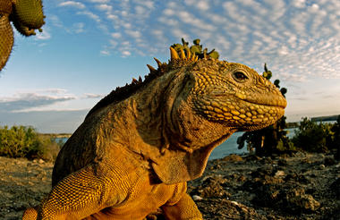
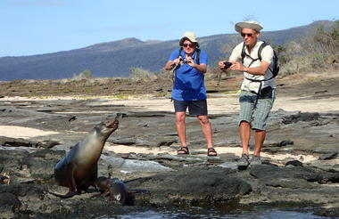

A small, vibrant jewel in the Galápagos archipelago, South Plaza Island is a striking study in contrasts. Its rugged cliffs rise sharply from turquoise waters, while the interior is carpeted with bright orange and green sesuvium plants, creating a kaleidoscope of colours. The island teems with life: colonies of sea lions lounge lazily on sun-warmed rocks, swallow-tailed gulls wheel overhead, and striking land iguanas patrol the sunbaked terrain. Visitors can wander along narrow trails that weave through dramatic cliffs and cactus-studded landscapes, or snorkel in the surrounding waters, where playful fish dart among the waves. The salty tang of the ocean blends with the hum of seabird colonies, offering an intimate sensory experience with one of the Galápagos’ most vibrant and unique islands.


Located in Santa Cruz Island, the second largest in the Galapagos, Puerto Ayora is located in the southeast of this large, round volcanic island is the economic center of the Islands. It has the largest population among the four inhabited islands (approx. 18,000), which economically relies mostly on tourism—including refurbishing and resupplying Galapagos cruise yachts—along with fishing and boat-building.
Puerto Ayora is home to both the Galapagos National Park Service Headquarters and Charles Darwin Research Station, the center of the great restorative efforts taking place in the park, a UNESCO World Heritage site. Here we go ashore to visit the Giant Tortoise Breeding and Rearing Program run by the research station, which began by rescuing the remaining 14 tortoises on the island of Española in 1970. This program has restored the population of animals there to over 1,000 today. You will see many of these animals, with their sweet ET necks and faces; from hatchlings to juveniles to large, distinguished individuals like Lonesome George, the last of his particular race of tortoises. The local color of this port makes for an attractive stop-off, with restaurants, souvenir shops, and internet cafés
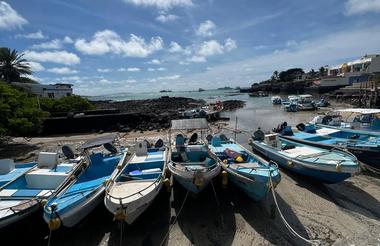


Santa Cruz Island is composed of two parts: a younger and larger portion is formed by many volcanic cones and basaltic lavas, while the older part is a narrow, 10-mile strip of land along the northeastern coast and consists of uplifted submarine lava flows and tuffs.
Santa Cruz Island is the second-largest island in the Galapagos and something of a hub for the archipelago. Puerto Ayora, located in the southeast of this large, round volcanic island, is the economic center of the Islands.
Puerto Ayora is home to both the Galapagos National Park Service Headquarters and Charles Darwin Research Station, the center of the great restorative efforts taking place in the park, a UNESCO World Heritage site.
A highlight of any trip is a visit to Santa Cruz Highlands, where the dry coastal vegetation transitions to lush wet fields and forests overgrown with mosses and lichens. Our destination is the Tortoise Reserve, where we will have chances to track and view these friendly and ancient creatures in their natural settings. This extends to the adjacent pasturelands, where farmers make some profits by allowing visitors into their farms in exchange for payment. The best time to see tortoises here is during the cold or dry season from June through December. Another nearby attraction is the highland lava tunnels. Some of them offer easy access through wooden stairways that descend to the mouth of their arched cave entrances. From there, one can make their way into the caves underground along the cool, dimly lit naturally formed passages with their fascinating rock formations. The tunnels make for a relatively easy and exciting hike. You should bring along non-slip footwear and some hikers prefer to use a flashlight.


Isabela Island is the largest island in the archipelago, accounting for half of the total landmass of the Galapagos at 4,588 square kilometers. Though narrow in places, the island runs 132 km from north to south or 82 miles. Isabela Island is formed from six shield volcanoes that merged into a single landmass. It is also home to the highest point in the Galápagos, Wolf Volcano at 5,547 feet, and calderas of up to 7 miles across.
This Island is formed by five relatively young volcanoes and one, which is very eroded, called Ecuador Volcano. The volcanoes Wolf, Cerro Azul, Alcedo, and the northwestern flanks of Sierra Negra have sporadic activity. The northern volcanoes have broad fields of lava and very little vegetation except for the humid and protected areas.
Located in the south of the northwesternmost point of Isabela Island is Punta Vicente Roca. On the map, this place looks like the head of a sea horse. Here the remnants of an ancient volcano form a cove with a bay well protected from the ocean swells. The spot is a popular anchorage from which to take dinghy rides along the cliff where a partially sunken cave beckons explorers. Nazca and blue-footed boobies as well as brown noddy terns perched along with the point and the sheer cliffs, while flightless cormorants inhabit the shoreline. The upwelling of cold water currents in this part of the Galapagos produces an abundance of marine life which, in combination with the protection of the coves, makes Punta Vicente Roca one of the archipelago's most exciting dive spots where Galapagos sharks and many other sharks are often spotted. This place is right to practice some kayaking. The entire area of Punta Vicente Roca lies on the towering flank of 2,600 foot Ecuador Volcano. This is the island's sixth largest volcano. Half of Ecuador Volcano slid into the ocean leaving a spectacular cutaway view of its caldera.
On the way south of Isabela Island, to Tagus Cove, you will sail through the Bolivar Channel on your Galapagos cruise. These are the coldest, most productive waters in the Galapagos, the upwelling of the rich Cromwell current makes for frequent sightings of dolphins and whales in the area.
Puerto Villamil has a feeling of standing on the edge of the earth. The tiny fishing village, founded in 1897 by Don Antonio Gíl, is something of a forgotten gem in the islands. It has a population of roughly 2,000 people and is set amidst miles of white sandy beaches that rest at the outer edge of 4,452 ft. Sierra Negra Volcano.
Tagus Cove, named for a British naval vessel that moored here in 1814, was used historically as an anchorage for pirates and whalers. One can still find the names of their ships carved into the rock above our landing, a practice now prohibited, of course. The cove's quiet waters make for an ideal dinghy ride beneath its sheltered cliffs, where blue-footed boobies, brown noddies, and pelicans nests. Flightless cormorants and penguins inhabit the lava ledges near the ocean. From our landing, a wooden stairway rises to the trail entrance for a view of Darwin Lake, a perfectly round saltwater crater, barely separated from the ocean but above sea level! The trail continues around the lake through a dry vegetation zone and then climbs inland to a peninsula formed by spatter cones. The site provides spectacular views back toward our anchorage in the bay, as well as Darwin Volcano and Wolf Volcano farther to the north.
Urbina Bay is directly west of Albemarle Island's Alcedo Volcano, where we will make a reasonably easy wet landing (a hop into a few inches of water except when the shoreline is rough) onto a gently sloping inorganic beach. In 1954, a Disney film crew caught sight of this gleaming white strip, and on further investigation found pools of stranded sea creatures! To their astonishment, three miles (5 km) of the marine reef had been uplifted by as much as 13 feet (4 meters) in moments. Now visitors can walk amongst the dried coral heads, mollusks, and other organisms that use to form the ocean floor. A highlight of this excursion is tracking down the huge land iguanas that live in the area, whose vivid and gaudy yellow skin suggests that dinosaurs may have been very colorful indeed. Giant tortoises inhabit this coastal plain during the wet season, before migrating to the highlands when the lowlands turn dry. Our landing beach also provides opportunities to snorkel amongst marine creatures or relax on the beach. Here we must take care not to step on the sea turtle nests, which are dug carefully into the sand.
Buried pirates treasures were unearthed here in Sierra Negra some years ago in the shadow of a tall coconut palm, thereby giving credence to all the legends of hidden treasure buried beneath palm trees. It's possible to travel to the highlands by bus, from the base of the volcano to the Park Service post, from where we can have a 2-hour hike on reasonably steep terrain to the rim of the volcano. Measuring 10 km across, the caldera is the third-largest in the world after Ngorongoro in Africa and Caldera Las Cañadas in the Canarias. At the rim, we have some spectacular views of the caldera, the island, and the surrounding Pacific. We continue hiking for another 45 minutes to the sometimes active cone of Volcan Chico. This is a parasitic cone that protrudes from the northern side of the volcano. The most recent eruption with lava flows and fumaroles occurred in October 2005 and gave evidence of the birth and continued growth of the islands. In the afternoon, we'll return to Puerto Villamil. Along the way, we will visit a breeding station for the endemic giant tortoise lead by the National Park Service as well as a hyper-saline lagoon frequented by flamingos and other waders and shorebirds. We also plan some free time in town giving you the opportunity to relax in a local beachside bar.


The Galapagos Archipelago is a cluster of some 13 volcanic islands and associated islets and rocks located just under the equator, about 600 miles (1000km) west of Ecuador in South America.
The oldest of the islands is about 4 million years old, and the youngest is still in the process of being formed. These Islands that we visit on our Galapagos cruises are considered to be one of the most active volcanic areas in the world.
About 97% of the islands are part of the Galapagos National Park system, with the remainder being inhabited by about 14,000 people in four significant communities (Puerto Ayora, Puerto Baquerizo, Puerto Villamil, and Floreana). The Galapagos National Park Service and the Charles Darwin Research Station jointly operate the islands. The Park Service provides rangers and guides and is responsible for overseeing the many tourists who visit each year. The Darwin Station conducts scientific research and conservation programs. It is currently breeding and releasing captive tortoises and iguanas.
This group of 13 major islands and dozens of smaller islets and rocks - all the result of volcanic activity - indeed appear to be out of this world. They are, in fact, an unpredicted wilderness, filled with extraordinary populations of unique species, which have developed apart from humans and their dominating influence. To preserve the islands as they were centuries ago, the Galapagos have been declared a World Heritage Site by UNESCO.
The Galapagos Islands have low biodiversity (that is, few animal species) because the islands are 600 miles from the continent. This vast expanse of cold ocean in-between makes it very difficult for new kinds of plants and animals to reach the islands.
Marine organisms, such as green sea turtles and corals, probably came on their own, swimming, or as floating larvae. Sea birds are all strong flyers that frequently make long journeys across the open sea. But most of the Galapagos life forms reached the islands by accident, and all had a long sea voyage. During that trip, both plants and animals were exposed to salt water, drying winds, and intense sunlight. They had no freshwater or food. Galapagos reptiles are also more likely than land birds or mammals to be able to survive under these conditions. As a result, animals of the Galapagos Islands are species whose ancestors were already well suited for their harsh environments. Compared to elsewhere in the tropics, there are few birds or Galapagos mammals, and many essential groups are missing.
The archipelago is 600 miles off the coast of Ecuador in South America and belongs to Ecuador. Discovered in 1535 by Spanish Bishop Tomas de Berlanga, the Islands became famous when British Scientist Charles Darwin arrived in Galapagos in 1831 and based his theory of Evolution on his findings in the Galapagos


As previously described


As previously described


The island consists of a central volcano and calderas, numerous parasitic cones on the flanks, vast lava fields, and a few vegetated areas. It is one of the youngest volcanoes of the archipelago and the world.
Fernandina Island is the youngest and westernmost island in the Galapagos, which we visit on all our Galapagos cruises. It sits across the Bolivar Channel opposite to Isabela Island. The only visitor site is Punta Espinosa, a narrow spit of land in the northeast corner of the island, where several unique Galapagos species can be seen nearby. As the panga driver skillfully navigates the reef, it is not unusual to see penguins swimming nearby the dinghy. Red and turquoise-blue zayapas (Sally lightfoot) crabs disperse across the lava shoreline, while herons and egrets forage among the mangrove roots.
The landing at Punta Espinosa is a dry one, set in a quiet inlet beneath the branches of a small mangrove forest. A short walk through the vegetation leads to a large colony of marine iguanas - a schoolyard of Godzilla's children - resting atop one another in friendly heaps along the rocky shoreline, sneezing out saline water to clear their bodies of salt. Nearby, sea lions frolic in the sheltered coastline. Fernandina is one of the few places you can glimpse iguanas grazing on seaweed underwater and above!
Dominating this landscape of Fernandina Island is La Cumbre volcano. At 1495 meters ( 4,858 feet ), it is one of the most active volcanoes in the world, reporting seven eruptions from its 6-kilometer-wide caldera (mouth) since 1968. Along the coastline, the world's only species of flightless cormorants have established their colony near an open inlet frequented by sea turtles. Because these birds evolved in Fernandina Island without land predators — it was easier to feed on the octopuses, eels and fish found in the ocean — the cormorants progressively took to the sea. They developed heavier, more powerful legs and feet for kicking, serpent-like necks and wet, fur-like plumage. Their wings are now mere vestiges. Back toward the landing and farther inland, the Fernandina Island's black lava flows become more evident, forming a quiet, inner lagoon. Galapagos hawks survey the seascape from overhead.


As previously described


Santiago Island has a volcanic landscape and it is common to see fur seals, flamingos, and hawks. Another important feature of Santiago Island is that it has almost all the vegetation zones, from arid to humid. Still, they have been severely affected by the intense browsing of introduced goats.
Santiago Island offers numerous scoria and tuff cones; extensive recent lava flows on the east and south of the island. One major volcano dominates the western side, which is thickly vegetated and highly eroded.
Just across a narrow channel west of Bartolome Island lies Sullivan Bay on Santiago Island. This landing offers one of the most outstanding volcanic sites in the Galapagos. Just over a century ago, the island gave birth to a field of lava called pahoehoe (“rope-like” in Hawaiian), which gleams like a gigantic obsidian sculpture. It is stirring to imagine the once-molten lava lighting up the earth, flowing into the sea, and sending plumes of superheated steam skyrocketing into the air. The flow gave birth to the new land as it engulfed vegetation, leaving some plants forever etched into the earth.
Today the flow stands as a gallery of abstract shapes resembling braids, curtains, and swirling fans. Brightly colored “painted locusts” and “lava lizards” punctuate the black volcanic canvas, as does the occasional finger of lava cactus and spreading carpetweed. Looking back across the bay from the source of the flow, a cinder cone of reddish lava, you are treated to a view of Pinnacle Rock nearby Bartolome Island.
On the northwestern side of Santiago Island in James Bay, which offers access on a Galapagos cruise to three unique sites, Puerto Egas, Salt Mine, and Espumilla Beach. The first landing, Puerto Egas, is the most visited area and begins with a wet landing on a black beach. With intriguing eroded rock formations inland, the trail crosses the dry interior eastward and continues along the shoreline, where two different types of lavas merge into unreal scenery. There we find the so-called Fur seal Grottos, the only place during your visit that allows you to see these beautiful marine mammals during a land excursion. Darwin describes his visit to Santiago Island and James Bay in Voyage of the Beagle.
From the black beach at Santiago Island, it is possible to experience one of the most exuberant snorkeling sessions during your visit.


Bartolome Island is famous for Pinnacle Rock, a towering spearheaded obelisk that rises from the ocean’s edge and is the best-known landmark in the Galapagos. Galapagos penguins—the only species of penguin found north of the equator—walk precariously along narrow volcanic ledges at its base. Sea lions snooze on rocky platforms, ready to slide into the water to play with passing snorkelers. Just below the surface, shoals of tropical fish dodge in and out of the rocks past urchins, sea stars and anemones.
A perfectly crescent sandy beach lies just to the east of the pinnacle. Sea turtles use the beach as a nesting site and could sometimes be found wading in the shallow water near the shore, or resting in the sand to recover from the arduous task of digging nests, laying eggs and covering them over. Penguins dot the nearby rocks of the next landing site, less than half a mile along the eastern shore. Here the submerged walls of a tiny volcanic crater give the impression of a fountain pool. This dry landing—no wet feet!—is the entrance to a 600-meter (2000-foot) pathway complete with stairs and boardwalks leading to Bartolome’s summit. The route is not difficult and presents an open textbook of vulcanology; a site left untouched after its last eruption, where small cones stand in various stages of erosion and lava tubes form bobsled-like runs from the summit. At the top, you will be rewarded with spectacular views of Santiago Island and James Bay to the west, and far below, Pinnacle Rock and our beach, where the crystal turquoise waters of the bay cradle your Galapagos cruise yacht.


