


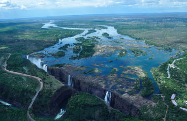
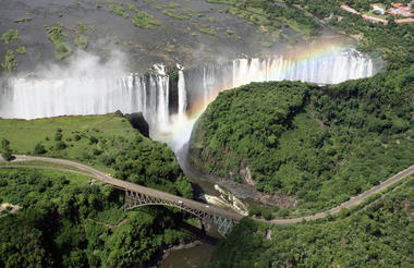
Understandably one of the wonders of the world, Victoria Falls is the principal tourist attraction in Zimbabwe.
The force of the mighty Zambezi River spilling into a gorge is one of the most enthralling sights in the world.
The local Makololo name for the falls is 'Mosi-ao-Tunya' which means the Smoke that Thunders. UNESCO recognised the significance of the falls and the surrounding area and gave it the World Heritage Site credential in 1989.
Victoria Falls town is where the tourist adventure starts. It lies on the south bank of the river close to the falls. It is served by a recently-upgraded international airport that has opened up the possibilities of direct linkages with the world. There are also rail and road connections from the town to the rest of the country.
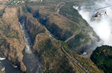
During different eras the river has fallen into different chasms, which now look like a series of sharp zigzag gorges downstream from the falls. There are 7 recognised gorges, the First, Second, Third, Fourth, Fifth, Songwe and the Batoka gorge across which the gorge swing activity takes place.
There is an array of activities that can be done below and above the falls and on the Zambezi. Whitewater rafting, river boarding, bungee jumping, abseiling and .... are the adrenaline-pumping activities that can be done here. For more relaxing activities, sunset cruises and canoeing can be done on the Upper Zambezi for the rich wildlife in the area or elephant rides, walking safaris and horseback trails can be booked in the surrounding national parks and smaller wilderness areas.
A part of the Upper Zambezi forms the Zambezi National Park, which together with the Victoria Falls National Park, the spray-drenched rainforest, covers an area of 56,000 ha.
The Zambezi National Park is stunningly wild and the tourist will surely quench his thirst for the most extravagant of visits to see large mammals, smaller mammals, almost 400 species of birds, beautiful forests of mahogany, figs and date palm trees and extraordinary views of the roaring falls from the Victoria Falls National Park.
The most visited part of the Chobe National Park is the Chobe riverfront around the Serondella area. It is situated in the extreme northeast of the park near to Kasane, which is located just downstream on the river and serves as the northern entrance to the park. Being the important town in this region with an airport with proximity to the Victoria Falls, this area makes up a good spot in the tourist itinerary. The area is close to where the Chobe meets the Zambezi at the confluence of 4 countries of Botswana, Namibia, Zambia and Zimbabwe.
Serondella has a beautiful landscape featuring lush floodplains and a dense woodland. In the past teak, mahogany and other hardwoods adorned this woodland but these have been put under immense elephant pressure. Chobe has one of the highest densities of elephants in the world and since the riverfront is a major watering spot especially in the dry season, visitors get to see a grand spectacle of the gray heavies.
Along with large herds of elephants, the area also hosts giraffe, sable, impala, buffalo and plains game like puku antelope. Waterbuck, reedbuck and red lechwe can be seen near the water feasting on the green grass. Birding is spectacular in this part of the park. Numerous cormorants, storks, geese, ducks, ibis, spoonbills, waterfowl, egrets, herons and other common water birds are found here. Hundreds of carmine bee-eaters are seen fluttering in season. Also seen are kingfishers, hammerkops and loads of raptors.
Though the popularity of the Serondella area means that the riverfront is busy with 4X4 vehicle safaris (preferred in the mornings) and boat safaris (preferred in the afternoons), this part of the park still remains an ideal location to spend at least 2 nights to grasp the beauty of the place and have the sightings of a lifetime.


The Savuti channel from the Linyanti feeds the Savuti marsh, an area famous for being a stage for a dramatic and fascinating safari experience owing to its location and landscape. The peculiarity of the channel is that it stopped flowing completely from 1888 to 1957 and then from 1980 to 2008 and started flowing again, first creating grasslands then a clear waterway home to aquatic life and a new source of water for the wildlife. It is tucked away in the heart of Chobe National Park.
The landscape of the Savuti (also spelled Savute) is diverse with lush grasslands in some areas and desert-like stretches with camelthorn acacia trees in others. The Gubatsa Hills located in the area were formed nearly one billion years ago due to volcanic activity. These dolomite rock outcrops rise to a mighty 290 feet high out of nowhere creating a beautiful contrast landscape.
The seasonal rains create many waterholes around the region leading to a congregation of big groups of animals in the dry season. Large lion prides have been seen around the area feasting on the abundant plains game like tsessebe, wildebeest and especially zebras that pass through the region for their annual migration to the grasslands of the Mababe Depression. Lions have also been seen attacking elephants that are found in plenty having a tug of war over the water sources. Endangered wild dog is a promising find here.
Lions have found competition in cheetah and hyena as predators while leopard, jackal and bat-eared fox are also spotted roaming around. While watching wildlife is an immense experience in this area, bird enthusiasts are also not disappointed. The diverse list of species includes kori bustards, red billed francolins, quelea finches and secretary birds to mention a few.
Usually accessed by air, the Savuti is nicely paired up with the Okavango Delta in the tourist itinerary. It is an exceptional destination as safari sightings are brilliant throughout the year and not only in the dry season. In the rainy season, there are countless migrant birds like Abdim's storks, carmine bee eaters and fish eagles arriving from the cold up north, baby animals like baby impala are born in hundreds and thousands of zebra migrate to grassier plains.
Camps are few and top-notch - The Savute Elephant Camp, Savute Safari Lodge and Savuti Camp (nearer to the channel than the marsh). These can be driven to or flown into (Game Reserve has an airstrip) though the road might be closed if the reserve gets good rain.


The Okavango Delta is an area of staggering pristine beauty offering beautiful ecosystems and the chance for the best wildlife safaris in Africa. It is one of the world's largest inland delta systems. The floodwater of the Okavango River gushes down through the Angola highlands through the northwestern part of Botswana and thins out over the Kalahari Desert forming around 15,000 km2 of an enchanting delta system. This is an annual occurrence from May through July and there is quiet period October onwards. This cycle of events results in a versatile nature of the delta system and hence there is a constant wildlife activity around this place throughout the year. It causes the migration of thousands of animals in addition to more than 400 species of birds and 1000 species of plants! This magnificence of the Delta has made it one of the Natural Seven Wonders of Africa.
The Okavango Delta is made up of two parts - the Moremi game reserve and a number of private reserves. The Moremi Game Reserve is a public place consisting of the Chief's Island where many self-drive tourists visit. The Chief's Island is where safari-related activities are permitted. The private reserves offer accommodation in small camps and exclusive activities to the resident guests who fly in to these camps by air in light aircraft from main airports at Maun and Kasane. Guest numbers are usually low and the services are top class offering a low-impact but high quality personalised experience to one and all. Also, since these are private, the guides are allowed some freedom during safaris. For e.g. they are allowed to do night-safaris with the guests and are allowed to move off course when spotting any wildlife. They do this with utmost caution and high expertise. Also offered are walking safaris not allowed in the national parks. Also one of the good ways to explore the Okavango is by horseback.
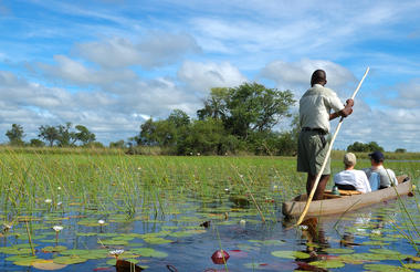
An Okavango Delta safari is a highly unusual and exciting because tourists haven't usually experienced the feeling of sitting in a traditional dug out canoe, locally called a 'mokoro' and watching the wild animals at close quarters. Waddling through the clear blue waters, you get this mystical feeling of being in a faraway land. Fish swim besides you shining in the heat while birds of prey await their time at a distance. Walking on the islands with an expert guide or exploring on horseback will take you real close to the wildlife. It is once in a lifetime experience to do this in the wild. This is the real Africa!
The wildlife is plentiful and gorgeous. With the reintroduction of rhino, it is a good place to get the Big Five out of your system! There are elephants all year round along with big herds of buffalo, giraffe, impala, zebra, kudu, waterbuck, bushbuck, reedbuck, tseesebe and many more. The predators include lion, cheetah, leopards frequently spotted at dusk, hyena and wild dog. Your guide will very likely also spot a large variety of birds, many which are particular to their preferred habitats. There are egrets, cranes, hornbills, eagles, kingfishers, jacanas, firefinches, storks, ibis, owls and coucals. You might also spot otters swimming across the waters in certain places. On night drives you might be lucky to find civets, servals, porcupines, honey badger and white tailed mongoose.
May to October is the dry season whence there are huge numbers of animals congregating towards the delta in search of water and food. In the 'green' season from December to April, most migrants have moved out leaving the residents behind along with a lot of baby animals and beautiful surroundings. This is also a good time to spot the nesting of few migrant birds. Most dry part of the delta is dominated by mopane woodland. Other than mopane, the papyrus and reed rafts make up most of the vegetation and during the flood season, they float on the water giving shelter to crocodiles in the gap between plants and river beds.
The camps in Okavango Delta are categorised as 'wet', 'dry' or 'mixed' according to the nature of the habitat near which they are situated. The wet camps offer mokoro safaris when the flow of the river is subtle and boating safaris when the river is in flood. They are set near very picturesque locations and can offer great wildlife views. The dry camps offer land-based safaris and are great to view big game and predators. The mixed camps, as the name suggests, offer walking, driving and boating safaris since they are located in areas with not much flooding but with enough dry areas to do dry camp activities.
There are nineteen sub-areas in Okavango each having it's own camps so there is lot to choose from when thinking about a best-suitable itinerary for any guest. The type of camp that's chosen will be in accord with the guest's interest, time of the year and budget. Hence it is possible to mix and match and opt for an amazing holiday at 2 or 3 different camps that might also be connected via the waterway.
The different sub-areas or concessions as they are called are: Abu, Chitabe, Duba Plains, Gudigwa, Gunns, Jao Flats, Khwai River, Kwara, Moklowane, Moremi Central (heart of the delta), Moremi Mopane, Nxabega, Okavango Mababe, Okavango Selinda South, Ranns, Shinde, Stanleys, Starlings and Vumbura.
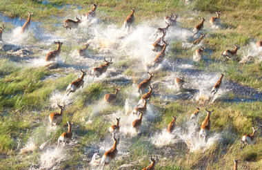
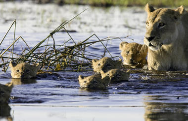
Moremi Game Reserve is a very special reserve situated in the central and eastern areas of the Okavango Delta and was the first to be established by local residents. It was declared a game reserve in 1963 after uncontrolled hunting and cattle encroachment led to the rapid decline of wildlife in the area. The Batawaana people of local Ngamiland led the formation under the guidance of the local chief, Chief Moremi's widowed wife. The location and environmental conditions have made it one of the most scenic and diverse in the continent. There are both public campsites and luxury lodges to fulfill the accommodation requirements and enjoy the views of the reserve. Most of the reserve is accessible only by flying in and boat and road journeys can be undertaken only to the fringes of the reserve or to the Chief's Island and some parts of the Mopane Tongue.
The reserve is just under 5000 sq km but is exceedingly beautiful with a combination of floodplains, lagoons, pools, riparian and riverine forests, pans, grasslands and mopane forests. It covers around 20% of the Delta's wetland and the dry peninsula called Mopane Tongue that cuts through the delta. A vast variety of wildlife makes game viewing and bird watching a delight for the visitor. It is a 'Big Five' destination with the recent reintroduction of the White and Black Rhino. Wild dogs, one of the most endangered species, are collared by researchers for conservation purposes that has led to an increase in their numbers. The wildlife is is prolific and quite used to the human presence which allows visitors to observe them closely. It is one of the few places where you can spot the rare Pel's fishing owl.
Elephants are usually numerous especially in the dry season as are other species like giraffe, buffalo, cheetah, lion, leopard, hyena and jackal. This is one of the best areas to spot the red lechwe and other antelope species are present all over the reserve according to the suitable habitat.
A good number of camps have been established inside the reserve, Chief's Island being prime property. Some patches on the Mopane tongue are accessible by a mobile safari on the confluence of land and water. These include Khwai River Area, Xakanaxa Lagoon and Third Bridge. Self-drivers usually combine Moremi with the Chobe National Park both different landscapes with amazing potential for game viewing.
Chief's Island is a dry piece of land towering at a height above the water filled delta, is huge and most likely Okavango's most famous island. It was once the royal hunting ground of Chief Moremi who contributed it to the Moremi Game Reserve making it the region's best game viewing areas. The camps here offer a personal and exclusive experience whilst abiding by the National Park rules. It is accessible by mekoro trips from the inner delta lodges.
Khwai River Area is another pristine area to the northeastern side of the reserve where the current headquarters of the reserve are located. There is a good density of prey and predator while birdlife is consistently excellent. The Khwai river forms the northern boundary of the reserve and the North Gate offers good photo ops and scenic views of the river from the large public campsite. Also present is the Khwai River Lodge which has stunning views of the reserve. It is accessible from Kasane and the east by a link through the Chobe National Park.
The South Gate of the reserve (Maqwee) is accessible at around 99 km from Maun. It also houses a campsite with two ablution sites in a woody area. Several species of game are found wandering around stands of acacia and in the open areas.
Another rustic camping ground is located at Third Bridge which can be accessed from the South Gate on a scenic road across the First and Second Bridges. This is an area with open plains and several thick foresty areas. Animals are plenty and mobile safaris might provide boat trips to the islands from the water-land boundary here.
On the way through the mopane forests, from the South to the North Gate, one more public camping ground can be reached at Xakanaxa lagoon. It is at the tip of the Mopane Tongue and at the heart of the reserve. This is an area with waterways and flooded areas that attract quite a lot of game and hunters like the shy cheetah are hence commonly seen. So are many waders as well as raptors.
Around 30 km from here is an area known as the Hippo pool, the residents of which can be viewed from an observation platform above the pool. Some roads are closed in the rainy season, like the one from Xakanaxa to Khwai.
Fuel and supplies are available in Kasane and Maun and a limited goods supply in Khwai.


