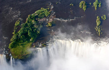
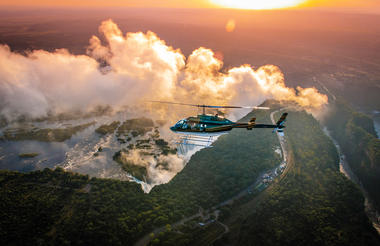
At Victoria Falls, the earth splits open and swallows one of Africa’s greatest rivers, the mighty Zambezi, creating the largest sheet of falling water on earth. As the water hits the narrow depths of the Batoka Gorge beneath, it blasts a cloud of mist skywards, lending the falls their local name ‘mosi-oa-tunya’ (the smoke that thunders). When the Zambezi is its fullest, the mist hangs a permanent raincloud above the falls, showering visitors on even the sunniest of days and visible for miles around.
Above the falls on the upper Zambezi, boats cruise the tranquil water at sunset while the distant spray catches the fading light downstream. Below the falls, the Batoka Gorge’s rocky walls funnel the lower Zambezi into a chain of world-class rapids, prime for white water rafting.
Aside from being a UNESCO world heritage site and a natural world wonder, Victoria Falls also forms a natural border between Zimbabwe and Zambia. The falls can be seen from both countries, and for the most part the same activities are offered on both sides, from helicopter scenic flights to village visits and souvenir shopping.
Whether your idea of getting away from it all is a relaxed high tea in colonial grandeur or a heart-stopping bungee jump off a bridge, Victoria Falls keeps both the faint of heart and the most insatiable of adrenalin junkies busy for days.
From Zambia, a side on view of the falls is on offer with views into the Batoka Gorge, as well as the possibility of perching yourself at the edge of the falls on the vertigo-inducing Livingstone Island.
From Zimbabwe, you’ll get a full-frontal view of three quarters of the falls’ 1.7km wide curtain of water from viewpoints and footpaths meandering through a rainforest kept hot and humid by the spray of the falls.
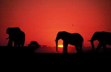
The Chobe Riverfront is an elephant mecca; home to the largest density of African elephants in the world. Travel here during winter and you’ll fast run out of fingers and toes while you count them drinking at the riverbanks and socialising out on the floodplains.
Thanks to its ease of access from Victoria Falls, the Chobe Riverfront is the busiest part of Botswana (though still a much quieter affair than most South or East African safaris). What Chobe lacks in solitude during the busier months, it more than makes up for with quality game viewing.
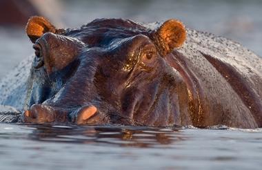
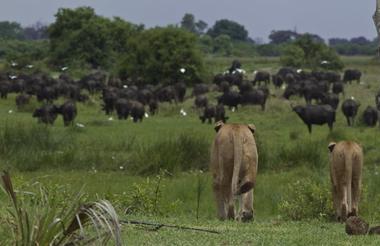
Chobe will leave you feeling tiny as giant elephant bulls stroll up next to your vehicle or snorkel alongside your boat. It will make you feel lost as hundreds of hippos and buffaloes crowd you out on the floodplains. It will put your heart in your throat as prides of lions stalk antelopes by the water’s edge, and it will leave you alone with your thoughts while the classic red sunsets melt over the river to a soundtrack of whistling fish eagles.
Chobe is not just a great introduction to Botswana. It also makes a rewarding repeat journey once you’ve ticked off the big stuff. It’s a place to search for the rare sable antelope, to spot that gem from the birders’ bucket list and to explore the remoter corners.
Where you stay in Chobe makes a huge difference to your safari experience. The most affordable options are at bigger hotels in a town setting where you’ll share your game drives with a few more vehicles. On the more exclusive end, stay in a wilder area in or around the park, listen to the sounds of the bush at night and get a head start on accessing the park for activities.
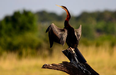
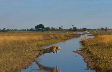
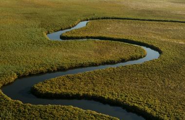
The Okavango Delta is where the wild things are: an immense, waterlogged oasis alive with elephants and birdlife, adrift in the middle of Kalahari sands. The real magic of the Delta lies in its water, trickling through from far away highlands, and spreading across the channels and floodplains.
During winter in the Kalahari, when the sun has baked the earth bare and turned the desert its driest, water fills the Okavango; transforming the floodplains into a Noah’s Ark of African wildlife.
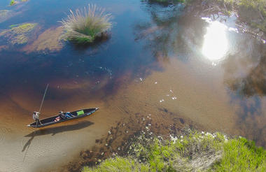
As the water brings life to the delta, its local residents shape and recreate it. Termites slowly build mounds into islands, germinated with palm trees by passing elephants. Waterways open and close on the whim of wide-bottomed hippos, carving out channels where they crash through reeds, and leaving room behind them for exploration by mokoro.
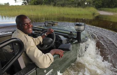
The Okavango has many faces, which change throughout the year, prompted by that most unpredictable diva of all: the weather. Water levels rise and drop, expanding and shrinking islands, while animals move where the life is easiest and the grass greenest. In a few days, a sandy road driven by vehicle can become a waterway of unknowable depth, prompting a safari by boat instead.
Where and when you stay in the Okavango Delta will hugely influence what you do in the bush each day, the animals you’re most likely to see and finally, the safari experience you’ll have.
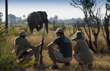
The delta’s watery heart is best discovered by mokoro through shallow channels and floodplains, as well as crossing the islands on foot. For less water and more of the big game, visit a camp on its drier edges (including Moremi Game Reserve and the Khwai Community Area), jump on a vehicle and seek out the animals hiding in the woodlands.
As previously described
The Makgadikgadi Salt Pans are all that remains of a great lake which once covered most of northern Botswana, fed by rivers carrying salts. The most iconic pans, Ntwetwe and Sua Pan provide vistas of blinding white salt flats reaching far into the horizon where pans sleep-outs are experienced. No vegetation grows on the salty surface of the pans, but the fringes are covered with grasslands. No animals live on the pans, save a few populations of desert species and the elusive brown hyena living near the fringes. The result is that the salt pans provide an unforgettable landscape experience of incredible sunsets and sunrises and a bewildering lack of perspective rather than a game experience. Africa’s famous explorer Dr. David Livingstone crossed these pans in the 19th century, using two massive baobabs, believed to be 3,000 to 4,000 years old as a navigation tool.
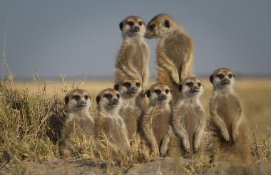
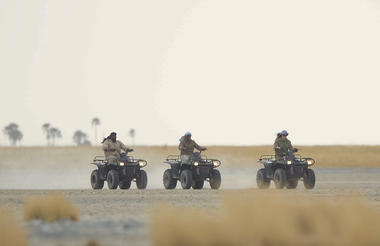
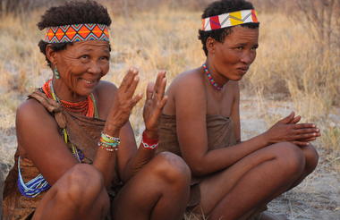
All camps on the salt pans are situated on or next to Ntwetwe Pan in the west of the pans complex and offer quad biking on the pans, visits to habituated meerkats, archaeological walks as well as cultural insight into the lives of the San people. More recently horse-riding expeditions have been made possible, providing a unique way to explore the landscape. All activities in this area are subject to favourable conditions as the slightest rainfall can make the pans completely inaccessible. During the rainy season, the main attraction of these camps is the zebra and wildebeest migration passing through during the early months of the year with other activities during this season being very limited. During years of good rains, the pans can be transformed into a powder blue lake with waters gently lapping the shorelines – a clear indication of the gigantic lake the Makgadikgadi once was. The floods attract flamingos with numbers running into the tens or even hundreds of thousands but the spectacle is fleeting and difficult to catch. Camps located on and next to the pans are Camp Kalahari, Jacks Camp and the seasonal San Camp, operating only during dry season. Accommodations in Gweta also access this part of the pans, running overnight trips to the area.
Sua Pan is the eastern-most of the large pans and is separated from Ntwetwe Pan by a thin strip of grass. One of the most striking destinations in this area is Kubu island, a rocky outcrop near the south-western edge of Sua Pan accessible only by quad bike expeditions of several days from Camp Kalahari, Jack’s Camp and San Camp or by self-drivers. This crescent-shaped island is about one kilometer long and apart from its eerie isolation and breathtaking beauty, Kubu is rich in archaeological and historical remains. Stone age tools and arrowheads can still be found today along the shorelines of this tiny island and a circular stone wall and stone cairns suggest that Kubu may have been part of the outer-reaches of the Great Zimbabwe Empire that was based at Masvingo, in modern-day Zimbabwe.