
Ecuador, a jewel of 109,483 square miles in northwestern South America, sits proudly on the Equator between Colombia and Peru. This enchanting land is home to the majestic Northern Andes, the verdant edges of the Amazon Basin, and a Pacific coastline caressed by both warm and cold ocean currents. Farther out, 600 miles offshore, the legendary Galapagos Islands await—a world of wonder and discovery.
From the towering peaks of the Andes to the vibrant biodiversity of the Galapagos, Ecuador promises an experience unlike any other. Here, ancient cultures thrive alongside stunning natural beauty, inviting you to explore, connect, and marvel. Whether hiking among volcanic landscapes, wandering through historic colonial cities, or encountering wildlife found nowhere else on Earth, Ecuador will leave you inspired and transformed.
Different parts of the island have varied origins, some with fresh lavas and spatter cones and others consisting of eroded tuff formations. Baltra Island used to be a US Air Force Base during World War II.
American soldiers in Baltra Island patrolled the nearby waters of the Pacific Ocean, including the entrance to the Panama Canal, for enemy aircraft carriers, warships, and submarines. When the war ended, the facilities in Baltra Island were handed over to the Ecuadorian Government.
Up until 1986, Baltra Island was home to the only airport in the Galapagos Islands. The airport now shares flights to the Galapagos with the San Cristobal Island airport, but it still receives the majority of flights from the mainland. Most cruise operators also start their cruise operations from Baltra Island. Also, because of its proximity to the largest port town in the Galapagos Islands (Puerto Ayora), most tourists who do island-based tours choose to arrive at the airport on Baltra Island.


Santa Cruz Island is composed of two parts: a younger and larger portion is formed by many volcanic cones and basaltic lavas, while the older part is a narrow, 10-mile strip of land along the northeastern coast and consists of uplifted submarine lava flows and tuffs.
Santa Cruz Island is the second-largest island in the Galapagos and something of a hub for the archipelago. Puerto Ayora, located in the southeast of this large, round volcanic island, is the economic center of the Islands.
Puerto Ayora is home to both the Galapagos National Park Service Headquarters and Charles Darwin Research Station, the center of the great restorative efforts taking place in the park, a UNESCO World Heritage site.
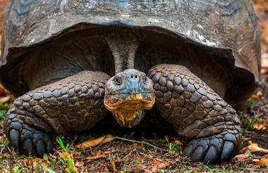
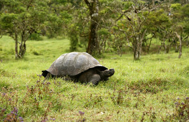
A highlight of any trip is a visit to Santa Cruz Highlands, where the dry coastal vegetation transitions to lush wet fields and forests overgrown with mosses and lichens. Our destination is the Tortoise Reserve, where we will have chances to track and view these friendly and ancient creatures in their natural settings. This extends to the adjacent pasturelands, where farmers make some profits by allowing visitors into their farms in exchange for payment. The best time to see tortoises here is during the cold or dry season from June through December. Another nearby attraction is the highland lava tunnels. Some of them offer easy access through wooden stairways that descend to the mouth of their arched cave entrances. From there, one can make their way into the caves underground along the cool, dimly lit naturally formed passages with their fascinating rock formations. The tunnels make for a relatively easy and exciting hike. You should bring along non-slip footwear and some hikers prefer to use a flashlight.


As previously described


By definition, this is a bird Island! Also known as Tower Island, this island is home to red-footed boobies, masked boobies, frigate birds and swallow-tailed gulls nesting. Moreover, red-billed tropicbirds nest on the cliffs and short-eared owls are often spotted. The vegetation of Tower Island is typical of the Arid Zone, and the tree called palo santo (holy stick) is small in size and abundant.
Genovesa Island lava originated primarily from a crater found in the center of the island, forming a shield volcano. The crater is circular, approximately 2000 feet wide at the rim and 200 feet deep, with a lake 1150 feet across on its floor.
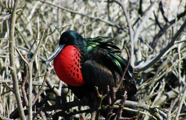
Genovesa Island is possibly one of the most exciting Islands of the archipelago to visit on a Galapagos cruise! It could serve as a film set for a secret submarine base! The southwestern part of Tower Island is an ocean-filled caldera ringed by the outer edges of a sizeable and mostly submerged volcano. The island sits to the northeast, somewhat removed from the Galapagos archipelago. It is also known as "Bird Island," a name it lives up to in a spectacular way. Landing on the white coral sands of Darwin Bay and walking up the beach, you will be surrounded by the bustling activity of magnificent frigate birds.
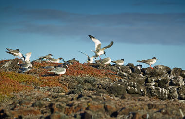
Puffball-chicks with their proud papas - who sport their bulging scarlet throat-sacks - crowd the surrounding branches, while both yellow-crowned and lava herons feed by the shore. Farther along, you will discover a stunning series of sheltered pools set into a rocky outcrop, forming another natural film set. A trail beside the pools leads up to a cliff overlooking the caldera, where pairs of swallow-tailed gulls, the only nocturnal gulls in the world, can be seen nesting at the cliff's edge. Lava gulls and pintail ducks ride the sea breezes nearby.
Across the bay is Prince Philip's Steps, named for a visit by the British Monarch in 1964. The 81-foot stairway leads to a narrow stretch of land that opens out onto the plateau surrounding Darwin Bay and extends to form the north side of the island. Red-footed boobies wrap their webbed feet around branches to perch in the bushes, and, in contrast, their "Nazca booby" cousins dot the surface of the scrublands beyond. Crossing through the sparse vegetation, you will come to a broad lava field that extends towards the sea-this forms the north shore. Storm petrels flutter out over the ocean in swarms, then return to nest in the cracks and tunnels of the lava field, where their predator, the short-eared owl, is a frequent visitor.


Darwin Bay is a nesting spot for many marine birds. Puffball chicks of Great frigate birds and their proud papas crowd the surrounding branches, while yellow-crowned herons and lava herons feed by the shore. Watch your step for marine iguanas, lava lizards and Galapagos doves that blend with the trail. Swallow-tailed gulls, the only nocturnal gulls in the world, can be seen nesting at the cliff’s edge. Lava gulls and pintail ducks ride the sea breezes nearby.
As previously described


Santiago Island has a volcanic landscape and it is common to see fur seals, flamingos, and hawks. Another important feature of Santiago Island is that it has almost all the vegetation zones, from arid to humid. Still, they have been severely affected by the intense browsing of introduced goats.
Santiago Island offers numerous scoria and tuff cones; extensive recent lava flows on the east and south of the island. One major volcano dominates the western side, which is thickly vegetated and highly eroded.
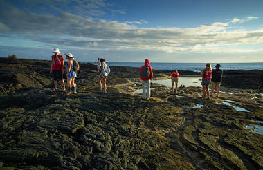
Just across a narrow channel west of Bartolome Island lies Sullivan Bay on Santiago Island. This landing offers one of the most outstanding volcanic sites in the Galapagos. Just over a century ago, the island gave birth to a field of lava called pahoehoe (“rope-like” in Hawaiian), which gleams like a gigantic obsidian sculpture. It is stirring to imagine the once-molten lava lighting up the earth, flowing into the sea, and sending plumes of superheated steam skyrocketing into the air. The flow gave birth to the new land as it engulfed vegetation, leaving some plants forever etched into the earth.
Today the flow stands as a gallery of abstract shapes resembling braids, curtains, and swirling fans. Brightly colored “painted locusts” and “lava lizards” punctuate the black volcanic canvas, as does the occasional finger of lava cactus and spreading carpetweed. Looking back across the bay from the source of the flow, a cinder cone of reddish lava, you are treated to a view of Pinnacle Rock nearby Bartolome Island.
On the northwestern side of Santiago Island in James Bay, which offers access on a Galapagos cruise to three unique sites, Puerto Egas, Salt Mine, and Espumilla Beach. The first landing, Puerto Egas, is the most visited area and begins with a wet landing on a black beach. With intriguing eroded rock formations inland, the trail crosses the dry interior eastward and continues along the shoreline, where two different types of lavas merge into unreal scenery. There we find the so-called Fur seal Grottos, the only place during your visit that allows you to see these beautiful marine mammals during a land excursion. Darwin describes his visit to Santiago Island and James Bay in Voyage of the Beagle.
From the black beach at Santiago Island, it is possible to experience one of the most exuberant snorkeling sessions during your visit.


At the geologic center of the archipelago, Rabida also known as Jervis Island, presents a different “look” from the other islands, with its reddish beach and cliffs and steep, sloping volcanic cinder-cones. A noisy colony of sea lions lives on the beach, and a short trail inland is an excellent place to observe land birds, including finches, doves, yellow warblers and mockingbirds. Along the beachside of Jervis Island, it's possible to find a small colony of brown pelicans nesting atop a saltbush forest during certain times of the year. Hidden behind this little forest lies a rather small hypersaline lagoon where flamingoes used to nest until some natural forces changed its condition in 1995. Snorkeling along the rocks at the east end of the beach reveals many reef fish common to these waters around Jervis Island in the Galapagos.


As previously described


As previously described


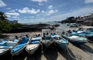
Located in Santa Cruz Island, the second largest in the Galapagos, Puerto Ayora is located in the southeast of this large, round volcanic island is the economic center of the Islands. It has the largest population among the four inhabited islands (approx. 18,000), which economically relies mostly on tourism—including refurbishing and resupplying Galapagos cruise yachts—along with fishing and boat-building.
Puerto Ayora is home to both the Galapagos National Park Service Headquarters and Charles Darwin Research Station, the center of the great restorative efforts taking place in the park, a UNESCO World Heritage site. Here we go ashore to visit the Giant Tortoise Breeding and Rearing Program run by the research station, which began by rescuing the remaining 14 tortoises on the island of Española in 1970. This program has restored the population of animals there to over 1,000 today. You will see many of these animals, with their sweet ET necks and faces; from hatchlings to juveniles to large, distinguished individuals like Lonesome George, the last of his particular race of tortoises. The local color of this port makes for an attractive stop-off, with restaurants, souvenir shops, and internet cafés


As previously described
As previously described


As previously described

As previously described
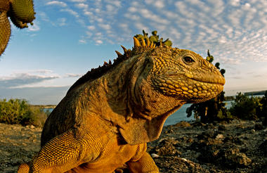
Santa Fe Island is one in which lavas were extruded beneath the sea and later were uplifted (although recent evidence suggests subsequent sub-aerial activity); the island is crossed by several parallel cliffs formed by fault activity. This island has lavas of 3.9 million years of age, making it the oldest island successfully dated in the archipelago.
Santa Fe Island besides offering one of the more beautiful and sheltered coves in the islands it also has endemic species of land iguana, endemic species of rice rat, subspecies of cacti, beautiful landscape. Its turquoise lagoon is protected by a peninsula of tiny islets forming an ideal anchorage. The island lies southeast of Santa Cruz Island within sight of Puerto Ayora. Geologically it is one of the oldest islands in the archipelago and for many years, was thought to be a product of an uplift event. Through satellite imagery, it has been possible to determine the island's volcanic origins.
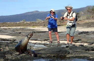
A Santa Fe Galapagos travel adventure includes a wet landing on a sandy white beach that brings visitors into contact with one of many sea lion colonies. Bulls contend for the right of being the Beach Master, while smaller males mask as females to make stealthy mating moves. Galapagos hawks are often easily approached, perched atop salt bushes, and an ascending trail leads toward the cliffs, where a dense thicket stands to the inland side. The cliffside provides an expansive view of the ocean. The giant prickly pear cactus found here live up to their name, with tree-sized trunks!

Floreana is composed of a series of eroded volcanic hills whose form makes it virtually impossible to identify a central volcano. There are no signs of recent volcanic activity.
As reflected in its many names, Floreana Island has had a colorful history: Pirates, whalers, convicts, and a small band of somewhat peculiar colonists—a self-proclaimed Baroness among them—who chose a Robinson Crusoe’s existence that ended in mystery and death. Today roughly a hundred Ecuadorians inhabit the island. In 1793 British whalers set up a barrel as Floreana Island's Post Office to send letters home on passing ships. The tradition continues to this day, only by dropping a postcard into the barrel without a stamp. The catch is you must take a letter from the barrel and see that it gets to the right place. That is how the system began and continues to this day.
Punta Cormorant in Floreana Island offers two highly contrasting beaches; the strand where we land is composed of volcanic olivine crystals giving it a greenish tint that glitters in the sun. We descend here on our Galapagos cruises, and a trail crosses the neck of an isthmus—that rises from behind a small cinder cone—to a beach of very fine white sand known as “Flour Beach.” The erosion of coral skeletons formed Flour Beach. Between the two shores of Floreana Island is a hyper-saline lagoon frequented by flamingoes, pintails, stilts and other wading birds. Some 700 ft. north from the point is an old submerged volcanic cone that has been worn down by waves; Devil's Crown is home to a myriad of marine species including several species of corals, sea urchins, and many other creatures including a significant number of fish species, making this place one of the best snorkeling sites in the Galapagos. The eroded crater walls of Devil's Crown form a popular roosting site for sea birds including boobies and pelicans.

As previously described


As previously described
Hood Island, or Espanola Island, is the southernmost island of the archipelago and is one of the most popular due to the breathtaking variation and a sheer number of fauna that greet the visitors.
A relatively flat island, with some hills; considered as one of the islands whose lavas were extruded beneath the sea and later uplifted to form the island. A group of geologists found evidence (1980) of volcanic activity, which occurred after the uplift.
On the northeastern shore of Hood Island, Gardner Bay offers a magnificent long white sandy beach, where colonies of sea lions laze in the sun, sea turtles swim offshore, and inquisitive Hood mockingbirds boldly investigate new arrivals. Your Galapagos cruise yacht will be anchored just a few hundred feet away. You will be lured into the turquoise water for a swim, but just a little further off-shore, the snorkeling by Tortuga Rock and Gardner Island offers peak encounters with playful young sea lions and large schools of surprisingly big tropical fish, including yellow-tailed surgeonfish, king angelfish and bump-head parrotfish. Sleepy white-tipped reef sharks can be seen napping on the bottom and sometimes Hammerhead sharks in a nearby location.
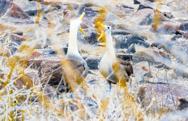
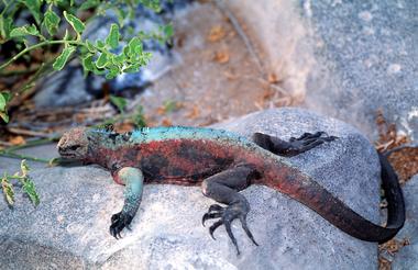
The quantity and variety of wildlife at Punta Suarez, on Hood Island, is remarkable. Sea lions surf the waves beyond the breakwater landing, and tiny pups are known to greet your toes upon arrival. A few steps inland you will find the most peculiar population of marine iguanas in the Galapagos. They bear distinctive red markings, some with a flash of turquoise running down their spine and legs, and nap in communal piles. The trail then takes us beside the western edge of the island where Nazca boobies (formerly known as Masked boobies) nest along the cliff’s edge and then descends to a rocky beach before rising to an open area and a large gathering of nesting blue-foot boobies. Galapagos doves, cactus finch, and mocking birds forage nearby, unconcerned by human presence on all of Hood Island. The trail continues to the high cliff edge of the southern shore; below, a shelf of black lava reaches out into the surf where a blowhole shoots a geyser of ocean water into the air. Within this area, along the cliffs is the “Albatross Airport” where “Waved albatross” line up to launch their great winged bodies from the cliffs, soaring out over the dramatic shoreline of crashing waves and driven spray. In the trees set back from the cliff is one of only two places in the world where the Waved albatross nests. In fact, the 13,000 pairs that inhabit Hood Island constitute a total endemic population of this species of birds, with the exception of a very small population that occasionally nest elsewhere on the continental part of Ecuador. Lucky visitors can watch courtship ‘fencing’ done with great yellow beaks and necks among the large, fluffy, perfectly camouflaged chicks. Mating occurs year-round.


As previously described

As previously described
San Cristobal Island is made up of two coalesced volcanoes. The southwestern half is asymmetric shield volcano made up of gently-dipping lavas and capped by a thick, deeply-weathered pyroclastic blanket and numerous satellite cinder cones. The southwestern shield became emergent around 2.4 million years ago; activity continued up to about 650,000 years ago. The northeastern half of the island is a more recently active volcano, dominated by eruptions from NE-trending fissures. The most recent flows are no more than a few centuries old.
San Cristobal Island is the only island with permanent freshwater, located near the highest part of the island (south) in a small lake called El Junco. The southern portion of the island is characterized by its rich vegetation, a result of the more humid climate.
Charles Darwin reported encountering a pair of giant tortoises feeding on cactus during his first landing on San Cristobal Island in 1835. Today the airport of this easternmost island in the chain is increasingly used as the arrival point for flights into and out of the Galapagos. The administrative capital for the province is Puerto Baquerizo Moreno on the southwestern shore, and in 1998 the Galapagos National Park Interpretation Centre opened for the benefit of islanders and travelers alike, presenting a comprehensive exhibit of the islands' natural history, human interaction, ecosystems, flora, and fauna. It is also the place where cultural activities take place, including theatre, exhibitions and workshops. From the Interpretation Center, a 3-kilometer loop trail arrives at Frigate Bird Hill, where both magnificent-frigates” and great-frigates can be seen in the same colony—ideal for learning to distinguish the two bird species. A 45-minute bus ride from town takes you to “El Junco,” one of the few permanent freshwater lagoons in the islands. Its location in the highlands of San Cristóbal ( 2,300 feet or 700 meters ) ensures our passage through a variety of vegetation zones. The lagoon on San Cristobal Island offers a scenic setting for exceptional bird watching including frigate birds that, in spite of being sea birds, go there to rinse the accumulated salt from their feathers.
Heading up the coast from Wreck Bay and Puerto Baquerizo, you will see Isla Lobos across a small channel off the coast of San Cristobal Island. This basalt island outcropping lives up to its name of “Sea Lion Island,” with its noisy population of frolicking and barking beasts. It is also a nesting place for blue-footed boobies and an excellent spot for snorkeling while on Galapagos cruises.
Playa Ochoa is located 6 miles from Puerto Baquerizo Moreno, the capital of San Cristobal Island and the Galapagos. The beach is small with easy access; here you'll find the Chatham mockingbird and various species of Darwin finches. Toward the rear of the beach is a little hyper-saline pond where white cheek pintails can often be seen wading. The beach also provides a chance for some introductory snorkeling.
Leon Dormido, also know as Kicker Rock, is a spectacular formation that rises 152 meters ( 500 feet ) out of the Pacific 4 miles off the central western coast of San Cristóbal. It takes the form of a sleeping lion or the Sphinx if you look at the rock from the south, but from the north, you can see that the stone is split, forming a large tablet and, piercing the sea, an excellent chisel ready for etching. Small vessels can navigate through the narrow channel between the two rocks that form Kicker Rock.
La Galapaguera is a tortoise reserve in seminatural conditions. This beautiful facility was built by the Galapagos National Park Service to provide the chance for visitors to San Cristobal Island to take a look at another race of giant tortoise, the Saddle Back. To reach the reserve, it's necessary to take a bus across the island from west to east. The ride takes 1 hour and the facility offers a dirt trail of easy access where 25 adult tortoises can be found in company with the very first babies to be born in captivity in this facility.


