

With its well-developed infrastructure, some of the best tourist facilities in Africa and an impressive list of breathtaking natural wonders, touring Namibia is truly a pleasure. Visit the capital of Windhoek and the lovely coastal town of Swakopmund to discover remnants of the country’s German influence, reflected in the architecture, culture, cuisine and the annual Oktoberfest celebrations. To properly appreciate this extraordinary country, you will have to venture out of the cities to explore the remarkable natural landscapes Namibia has to offer. These include: the impressive Fish River Canyon Park; the vast Etosha National Park teeming with local subspecies, such as desert lions, desert elephants and the Hartmann's Mountain Zebra; the hauntingly beautiful Kalahari Desert; and of course the Namib Desert stretching for nearly 1000 km along the magnificent Atlantic coastline. Namibia is an ideal destination for travellers seeking an unforgettable African experience in a uniquely beautiful untamed wilderness.
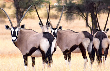
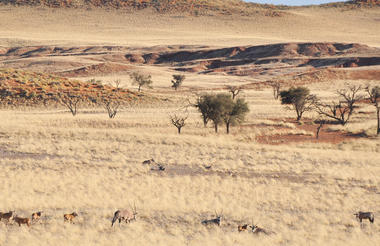
The Kalahari Basin covers most of Botswana and large parts of Namibia and South Africa. The name Kalahari means 'the great thirst' and describes the world’s largest continuous area of sand. It is an exceptionally beautiful semi-desert. In Namibia it is characterised by red dunes, acacia trees and wispy, mostly golden grass. The wide variety of wildlife includes gemsbok, impala, jackal and cheetah, not to forget the famous Meerkat. In all three countries the Kalahari is the last bastion of the indigenous San people who lived as hunter-gatherers in the whole of southern Africa before the modern world started to take over.


The Fish River Canyon is the most impressive natural wonder in southern Namibia. The canyon starts near Seeheim in the lower reaches of the Fish River and ends 160 km further south at Ai-Ais. It is an awe-inspiring gorge that meanders through the fissured Koubis massif at a depth of up to 550 metres. The Fish River Canyon is the second largest canyon in the world.
The canyon started to form about 500 million years ago during a pluvial episode – i.e. a period of intense rainfall. The huge gorge was not only created by water erosion, however, but also by the collapse of the valley bottom due to tectonic movement and by glaciation during the Karoo Ice Age.
The Fish River Canyon is part of the Ai-Ais/Richtersveld Transfrontier Park. The entrance gate is at the Hobas Campsite, from where it is 10 kilometres to the canyon and the most stunning view of the famous Hell's Bend.
The 86 km Fish River Canyon hike is very popular. But it is a tough challenge of 4-6 days and aspiring hikers have to prove their physical fitness with a medical certificate when they apply for a permit from Namibia Wildlife Resorts in Windhoek. Due to soaring temperatures during the summer months, the trail is open only from May to September.
Much easier, but no less scenically beautiful hikes are offered in the adjacent private nature reserves Canyon Nature Park and Gondwana Canyon Park, which also have excellent accommodation.


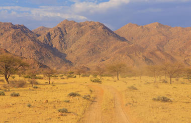
Tucked away in the rocky Aus Mountains on the fringe of the Namib plains, the small village of Aus is located in the south-western ǁKaras Region. The arid surroundings are known for their unique botanical diversity. Aus lends itself as an excellent base from which to explore the area and view the main attraction: the feral horses of the Namib Desert, which run wild and free on the sparsely vegetated plains. Catch a glimpse of these desert-adapted creatures at the water trough at Garub just 20 km away from the village.
Activities: Experience the Succulent Karoo on a visit to the beautiful Gondwana Sperrgebiet Rand Park, home to the most biodiverse desert in the world; take a scenic hike to discover fascinating indigenous fauna and flora; view the vast desert landscape from the back of a horse; camp under the dazzling Namibian night sky.


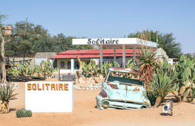
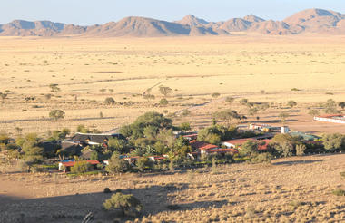
The desert town of Solitaire, in the south-western Khomas Region of central Namibia, is like a small oasis. There is not much to do or see in this tiny village, other than stop for refreshments and filling up with petrol. Solitaire boasts the only petrol station, general store and post office between Sossusvlei and Walvis Bay. There is also a small bar and a bakery famous for its apple pie – said to be the best in the country – as well as a luxury lodge, a motel and a campsite.
Activities: Enjoy a scenic sundowner with spectacular views of the Namib Desert; take time for a hike; go biking through unspoilt natural scenery; visit the local cheetah sanctuary.
As previously described

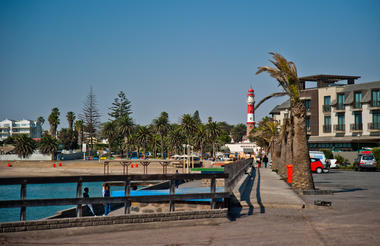
In 1892, eight years after South West Africa was declared a German Protectorate, Swakopmund was founded with the intention to build a harbour. By 1907 a little town pulsating with life had emerged from the desert! Swakopmund boasted the largest European population of all the German colonies in Africa. Decades on and much bigger now, the charming town is as alluring as ever. The mix of Namibian influences with picturesque buildings from the colonial era, palm-lined streets and seaside promenades, the laid-back holiday atmosphere plus the cool sea breeze make Swakopmund one of the most attractive places in the country.
Despite the turquoise waters of the Atlantic Ocean on its doorstep and the Namib Desert as its backyard, Swakopmund is not a tropical sunbathing paradise, however. The moderate climate along the coast is due to the cold Benguela Current. The current also causes the nightly fogs for which the town is famous and which sustain the wealth of desert flora and fauna near the coast. Early mornings and the evenings can be chilly throughout the year – a welcome respite from the inland heat.
Swakopmund has become the country’s adventure mecca. The desert, the dunes and the ocean lend themselves to a host of thrilling activities: sandboarding, sand skiing, quad biking, dune carting, beach angling and deep sea fishing, to name but a few, and not to forget parachuting.
There is no shortage of diverse shops, bistros and restaurants. Small specialist shops sell hand-made leather work, art & crafts, hand-woven carpets and wall hangings, hand-embroidered bed and table linen and other items proudly made in Namibia. Superb jewellery, designed and crafted with local gemstones by master goldsmiths, are another special feature of Swakopmund.
Activities other than fun in the sand and the sea: visit the art galleries and buy contemporary Namibian art and crafts; visit the museum to learn about Swakopmund’s history; join a tour of Karakulia Weavers and watch karakul wool being spun and woven into wall hangings and rugs; admire the world's largest quartz crystal cluster and other mineral treasures at the Kristall Galerie.


The small headland of Cape Cross lies on western Namibia’s Skeleton Coast, roughly 60 kilometres north of Henties Bay. The historic area was landed on by the Portuguese in 1486, and they erected a stone cross here in honour of the Portuguese King, however, this cross was replaced by the German settlers in the 1800’s. Cape Cross best known for its extraordinary breeding colony of Cape fur seals and has been made a reserve. With the abundance of fish swimming in the cold Benguela current, the seals have plenty to snack on, and they also enjoy lying and playing out in the sun. From a 200-metre-long walkway, visitors can watch the seals at play and learn about them through the area’s information points.


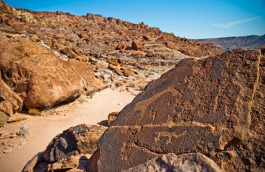
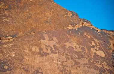
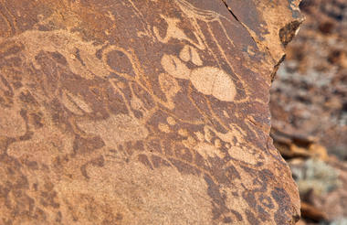
Twyfelfontein, in the Kunene Region of north-western Namibia, is one of the largest concentrations of rock art in Africa and Namibia's first World Heritage Site.
Thousands of tourists come to this site each year to view some 2, 500 Stone Age rock engravings. The area is home to 17 rock art sites, which collectively encompass 212 engraved stone slabs. There are an additional 13 sites displaying rock paintings. It consists of hundreds of sandstone slabs covered with rock engravings of animals, and there are a few paintings, too.
The enormous ‘open-air art gallery’ is found in the Huab Valley, flanked by flat-topped sandstone mountains. Twyfelfontein (spring of doubt) is the name that a despairing farmer gave to a perennial spring at the site in the late 1940s. The spring attracted Stone Age hunters over six thousand years ago. The petroglyphs had ritual significance and also served as maps, as well as for educational purposes and recording events.
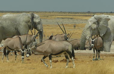
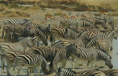
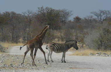
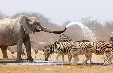
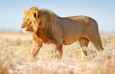
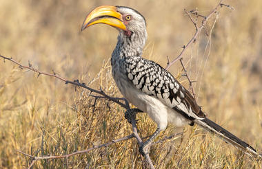
Etosha National Park in the central north is world-famous for its abundance of wildlife and premiere game viewing opportunities. The park is home to 114 species of mammals, including elephants, black rhinos, lions and other big cats and predators, giraffes, various antelopes and zebras, as well as hundreds of species of birds and reptiles. The vegetation ranges from dense bush to open plains with semi-arid savannah grasslands. During the dry season and in times of drought, the animals flock to the perennial springs and artificial waterholes which are maintained all over the park.
Etosha Pan in the heart of the nature reserve is a vast shallow depression of 5000 kilometres2 that can even be seen from space. The huge salt pan is dry for most of the year and lies shimmering in the heat, but after good rains it fills up with water and attracts scores of birds, especially flamingos from as far away as the Walvis Bay Lagoon on the Atlantic coast.
The western reaches of Etosha are quite different from its south-eastern and eastern parts. Even the characteristic white dust of the pan gives way to reddish-brown soil. The hills of western Etosha are the realm of Hartmann’s Mountain Zebra.
In most places in the park, the pans are devoid of vegetation with the exception of halophytic Sporobolus salsus, a protein-rich grass that is eaten by grazers like blue wildebeest and springbok. The areas around the Etosha pan also have other halophytic vegetation including grasses like Sporobolus spicatus and Odyssea paucinervis, as well as shrubs like Suaeda articulata. Most of the park is savanna woodlands except for areas close to the pan. Mopane is the most common tree, estimated to be around 80% of all trees in the park. The sandveld of north-eastern corner of Etosha is dominated by acacia and Terminalia trees. Tamboti trees characterize the woodlands south of the sandveld. Dwarf shrub savanna occurs areas close to the pan and is home to several small shrubs including a halophytic succulent Salsola etoshensis. Thorn bush savanna occurs close to the pan on limestone and alkaline soils and is dominated by acacia species such as Acacia nebrownii, Acacia luederitzii, Acacia melliferra, Acacia hebeclada and Acacia tortilis. Grasslands in the park are mainly around the Etosha pan where the soil is sandy. Depending on the soil and the effects of the pan, grasslands could be dominated by one of the Eragrostis, Sporobolus, Monelytrum, Odyssea or Enneapogon species.
Set on the TransNamib railway in central-north Namibia, near Etosha National Park, Otjiwarongo, meaning ‘the place of fat cattle’, is an affluent town with a suburban feel and numerous attractions. The town is known for its excellent conservation projects, which include several parks protecting large wild cats, such as the famous Cheetah Conservation Fund, and the Crocodile Ranch, where visitors can view and learn about these fascinating creatures. Hiking, guided nature walks, and safaris are popular activities. The lively, traditional craft market adds appeal. History enthusiasts should make sure to visit the Locomotive No 41 monument, and the culturally significant site of the Battle of Waterberg on the Waterberg Mountain.


