
Ecuador, a jewel of 109,483 square miles in northwestern South America, sits proudly on the Equator between Colombia and Peru. This enchanting land is home to the majestic Northern Andes, the verdant edges of the Amazon Basin, and a Pacific coastline caressed by both warm and cold ocean currents. Farther out, 600 miles offshore, the legendary Galapagos Islands await—a world of wonder and discovery.
From the towering peaks of the Andes to the vibrant biodiversity of the Galapagos, Ecuador promises an experience unlike any other. Here, ancient cultures thrive alongside stunning natural beauty, inviting you to explore, connect, and marvel. Whether hiking among volcanic landscapes, wandering through historic colonial cities, or encountering wildlife found nowhere else on Earth, Ecuador will leave you inspired and transformed.
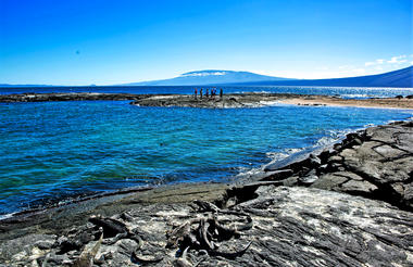
Different parts of the island have varied origins, some with fresh lavas and spatter cones and others consisting of eroded tuff formations. Baltra Island used to be a US Air Force Base during World War II.
American soldiers in Baltra Island patrolled the nearby waters of the Pacific Ocean, including the entrance to the Panama Canal, for enemy aircraft carriers, warships, and submarines. When the war ended, the facilities in Baltra Island were handed over to the Ecuadorian Government.
Up until 1986, Baltra Island was home to the only airport in the Galapagos Islands. The airport now shares flights to the Galapagos with the San Cristobal Island airport, but it still receives the majority of flights from the mainland. Most cruise operators also start their cruise operations from Baltra Island. Also, because of its proximity to the largest port town in the Galapagos Islands (Puerto Ayora), most tourists who do island-based tours choose to arrive at the airport on Baltra Island.


Santiago Island has a volcanic landscape and it is common to see fur seals, flamingos, and hawks. Another important feature of Santiago Island is that it has almost all the vegetation zones, from arid to humid. Still, they have been severely affected by the intense browsing of introduced goats.
Santiago Island offers numerous scoria and tuff cones; extensive recent lava flows on the east and south of the island. One major volcano dominates the western side, which is thickly vegetated and highly eroded.
Just across a narrow channel west of Bartolome Island lies Sullivan Bay on Santiago Island. This landing offers one of the most outstanding volcanic sites in the Galapagos. Just over a century ago, the island gave birth to a field of lava called pahoehoe (“rope-like” in Hawaiian), which gleams like a gigantic obsidian sculpture. It is stirring to imagine the once-molten lava lighting up the earth, flowing into the sea, and sending plumes of superheated steam skyrocketing into the air. The flow gave birth to the new land as it engulfed vegetation, leaving some plants forever etched into the earth.
Today the flow stands as a gallery of abstract shapes resembling braids, curtains, and swirling fans. Brightly colored “painted locusts” and “lava lizards” punctuate the black volcanic canvas, as does the occasional finger of lava cactus and spreading carpetweed. Looking back across the bay from the source of the flow, a cinder cone of reddish lava, you are treated to a view of Pinnacle Rock nearby Bartolome Island.
On the northwestern side of Santiago Island in James Bay, which offers access on a Galapagos cruise to three unique sites, Puerto Egas, Salt Mine, and Espumilla Beach. The first landing, Puerto Egas, is the most visited area and begins with a wet landing on a black beach. With intriguing eroded rock formations inland, the trail crosses the dry interior eastward and continues along the shoreline, where two different types of lavas merge into unreal scenery. There we find the so-called Fur seal Grottos, the only place during your visit that allows you to see these beautiful marine mammals during a land excursion. Darwin describes his visit to Santiago Island and James Bay in Voyage of the Beagle.
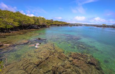
From the black beach at Santiago Island, it is possible to experience one of the most exuberant snorkeling sessions during your visit.


As previously described


As previously described


Isabela Island is the largest island in the archipelago, accounting for half of the total landmass of the Galapagos at 4,588 square kilometers. Though narrow in places, the island runs 132 km from north to south or 82 miles. Isabela Island is formed from six shield volcanoes that merged into a single landmass. It is also home to the highest point in the Galápagos, Wolf Volcano at 5,547 feet, and calderas of up to 7 miles across.
This Island is formed by five relatively young volcanoes and one, which is very eroded, called Ecuador Volcano. The volcanoes Wolf, Cerro Azul, Alcedo, and the northwestern flanks of Sierra Negra have sporadic activity. The northern volcanoes have broad fields of lava and very little vegetation except for the humid and protected areas.
Located in the south of the northwesternmost point of Isabela Island is Punta Vicente Roca. On the map, this place looks like the head of a sea horse. Here the remnants of an ancient volcano form a cove with a bay well protected from the ocean swells. The spot is a popular anchorage from which to take dinghy rides along the cliff where a partially sunken cave beckons explorers. Nazca and blue-footed boobies as well as brown noddy terns perched along with the point and the sheer cliffs, while flightless cormorants inhabit the shoreline. The upwelling of cold water currents in this part of the Galapagos produces an abundance of marine life which, in combination with the protection of the coves, makes Punta Vicente Roca one of the archipelago's most exciting dive spots where Galapagos sharks and many other sharks are often spotted. This place is right to practice some kayaking. The entire area of Punta Vicente Roca lies on the towering flank of 2,600 foot Ecuador Volcano. This is the island's sixth largest volcano. Half of Ecuador Volcano slid into the ocean leaving a spectacular cutaway view of its caldera.
On the way south of Isabela Island, to Tagus Cove, you will sail through the Bolivar Channel on your Galapagos cruise. These are the coldest, most productive waters in the Galapagos, the upwelling of the rich Cromwell current makes for frequent sightings of dolphins and whales in the area.
Puerto Villamil has a feeling of standing on the edge of the earth. The tiny fishing village, founded in 1897 by Don Antonio Gíl, is something of a forgotten gem in the islands. It has a population of roughly 2,000 people and is set amidst miles of white sandy beaches that rest at the outer edge of 4,452 ft. Sierra Negra Volcano.
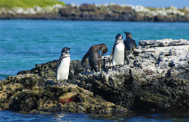
Tagus Cove, named for a British naval vessel that moored here in 1814, was used historically as an anchorage for pirates and whalers. One can still find the names of their ships carved into the rock above our landing, a practice now prohibited, of course. The cove's quiet waters make for an ideal dinghy ride beneath its sheltered cliffs, where blue-footed boobies, brown noddies, and pelicans nests. Flightless cormorants and penguins inhabit the lava ledges near the ocean. From our landing, a wooden stairway rises to the trail entrance for a view of Darwin Lake, a perfectly round saltwater crater, barely separated from the ocean but above sea level! The trail continues around the lake through a dry vegetation zone and then climbs inland to a peninsula formed by spatter cones. The site provides spectacular views back toward our anchorage in the bay, as well as Darwin Volcano and Wolf Volcano farther to the north.
Urbina Bay is directly west of Albemarle Island's Alcedo Volcano, where we will make a reasonably easy wet landing (a hop into a few inches of water except when the shoreline is rough) onto a gently sloping inorganic beach. In 1954, a Disney film crew caught sight of this gleaming white strip, and on further investigation found pools of stranded sea creatures! To their astonishment, three miles (5 km) of the marine reef had been uplifted by as much as 13 feet (4 meters) in moments. Now visitors can walk amongst the dried coral heads, mollusks, and other organisms that use to form the ocean floor. A highlight of this excursion is tracking down the huge land iguanas that live in the area, whose vivid and gaudy yellow skin suggests that dinosaurs may have been very colorful indeed. Giant tortoises inhabit this coastal plain during the wet season, before migrating to the highlands when the lowlands turn dry. Our landing beach also provides opportunities to snorkel amongst marine creatures or relax on the beach. Here we must take care not to step on the sea turtle nests, which are dug carefully into the sand.
Buried pirates treasures were unearthed here in Sierra Negra some years ago in the shadow of a tall coconut palm, thereby giving credence to all the legends of hidden treasure buried beneath palm trees. It's possible to travel to the highlands by bus, from the base of the volcano to the Park Service post, from where we can have a 2-hour hike on reasonably steep terrain to the rim of the volcano. Measuring 10 km across, the caldera is the third-largest in the world after Ngorongoro in Africa and Caldera Las Cañadas in the Canarias. At the rim, we have some spectacular views of the caldera, the island, and the surrounding Pacific. We continue hiking for another 45 minutes to the sometimes active cone of Volcan Chico. This is a parasitic cone that protrudes from the northern side of the volcano. The most recent eruption with lava flows and fumaroles occurred in October 2005 and gave evidence of the birth and continued growth of the islands. In the afternoon, we'll return to Puerto Villamil. Along the way, we will visit a breeding station for the endemic giant tortoise lead by the National Park Service as well as a hyper-saline lagoon frequented by flamingos and other waders and shorebirds. We also plan some free time in town giving you the opportunity to relax in a local beachside bar.


Puerto Villamil has a feeling of standing on the edge of the earth. The tiny fishing village, founded in 1897 by Don Antonio Gíl, is something of a forgotten gem in the islands. It has a population of roughly 2,000 people and is set amidst miles of white sandy beaches that rest at the outer edge of 4,452 ft. Sierra Negra Volcano.
As previously described


The spectacular Galapagos National Park is situated roughly 1000 kilometres off the coast of Ecuador on the Santa Cruz Island of the Galapagos archipelago. The Park is often referred to as a ‘living museum’ owing to its phenomenal melting pot of species. The area inspired the evolutionary theories of Charles Darwin and is considered to be a living laboratory where evolution is still in process. The park is home to a variety of animals and plants which do not exist anywhere else. These factors, along with the ongoing volcanic and seismic activity, has earned the park UNESCO status. Visitors can spot animals such as land iguanas, giant tortoises, a diversity of finches, and many other animal and plant species. Set at the confluence of three ocean currents, there is also an incredibly rich and abundant marine life offshore.


As previously described


As previously described


As previously described


The island consists of a central volcano and calderas, numerous parasitic cones on the flanks, vast lava fields, and a few vegetated areas. It is one of the youngest volcanoes of the archipelago and the world.
Fernandina Island is the youngest and westernmost island in the Galapagos, which we visit on all our Galapagos cruises. It sits across the Bolivar Channel opposite to Isabela Island. The only visitor site is Punta Espinosa, a narrow spit of land in the northeast corner of the island, where several unique Galapagos species can be seen nearby. As the panga driver skillfully navigates the reef, it is not unusual to see penguins swimming nearby the dinghy. Red and turquoise-blue zayapas (Sally lightfoot) crabs disperse across the lava shoreline, while herons and egrets forage among the mangrove roots.
The landing at Punta Espinosa is a dry one, set in a quiet inlet beneath the branches of a small mangrove forest. A short walk through the vegetation leads to a large colony of marine iguanas - a schoolyard of Godzilla's children - resting atop one another in friendly heaps along the rocky shoreline, sneezing out saline water to clear their bodies of salt. Nearby, sea lions frolic in the sheltered coastline. Fernandina is one of the few places you can glimpse iguanas grazing on seaweed underwater and above!
Dominating this landscape of Fernandina Island is La Cumbre volcano. At 1495 meters ( 4,858 feet ), it is one of the most active volcanoes in the world, reporting seven eruptions from its 6-kilometer-wide caldera (mouth) since 1968. Along the coastline, the world's only species of flightless cormorants have established their colony near an open inlet frequented by sea turtles. Because these birds evolved in Fernandina Island without land predators — it was easier to feed on the octopuses, eels and fish found in the ocean — the cormorants progressively took to the sea. They developed heavier, more powerful legs and feet for kicking, serpent-like necks and wet, fur-like plumage. Their wings are now mere vestiges. Back toward the landing and farther inland, the Fernandina Island's black lava flows become more evident, forming a quiet, inner lagoon. Galapagos hawks survey the seascape from overhead.


As previously described


As previously described


As previously described
At the geologic center of the archipelago, Rabida also known as Jervis Island, presents a different “look” from the other islands, with its reddish beach and cliffs and steep, sloping volcanic cinder-cones. A noisy colony of sea lions lives on the beach, and a short trail inland is an excellent place to observe land birds, including finches, doves, yellow warblers and mockingbirds. Along the beachside of Jervis Island, it's possible to find a small colony of brown pelicans nesting atop a saltbush forest during certain times of the year. Hidden behind this little forest lies a rather small hypersaline lagoon where flamingoes used to nest until some natural forces changed its condition in 1995. Snorkeling along the rocks at the east end of the beach reveals many reef fish common to these waters around Jervis Island in the Galapagos.


As previously described
As previously described


As previously described
