

Located in southwestern Africa, Namibia boasts a well-developed infrastructure, some of the best tourist facilities in Africa, and an impressive list of breathtaking natural wonders. Visitors can explore the capital of Windhoek and discover the lovely coastal town of Swakopmund, which boasts remnants of the country’s German influence, reflected in its architecture, culture, cuisine, and the annual Oktoberfest celebrations. To properly appreciate this extraordinary country, you will have to venture out of the cities to explore the remarkable natural landscapes Namibia has to offer. These include: the impressive Fish River Canyon; the vast Etosha National Park teeming with abundant wildlife, such as lions, desert-adapted elephants and the Hartmann's Mountain Zebra; the hauntingly beautiful Kalahari Desert; and, ofcourse, the Namib Desert stretching for over 2000 km along the magnificent Atlantic Coast. Namibia is an ideal destination for travellers seeking an unforgettable African experience in a uniquely beautiful, untamed wilderness.

Set in the heart of Namibia’s Otjozondjupa region, Otjiwa Game Reserve spans 12,000 hectares of open bushveld, rolling plains and acacia-studded savanna. The reserve exudes a serene and private atmosphere, where wildlife roams freely, and the horizon stretches unbroken beneath vast African skies. Visitors can embark on guided game drives to spot giraffe, zebra, antelope and rhino, or enjoy walking safaris that reveal the subtle rhythms of the bush. At sunrise, the air carries the scent of dry grass and earth, while the calls of birds and distant wildlife punctuate the quiet, a place where Namibia’s wild beauty is both immersive and unforgettable.
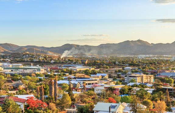
Windhoek is the capital of Namibia, located in the central highlands of the country. South of the city, the sprawling Heroes' Acre war memorial commemorates Namibia's independence in 1990. On a hill in the city center stands the Old Fort, dating back to the 1890s, which was a former military headquarters with historical exhibits, and the Independence Memorial Museum. Colonial influences are visible in nearby buildings such as the Lutheran Christ Church made of sandstone, as well as in the Victorian buildings lining the streets of Windhoek.
THINGS TO DO
- National Museum Namibia (www.museums.com.na/museums/ windhoek/national-museum-of-namibia)
- Independence Memorial Museums (www.museumscom.na/ museums/wind-hoek/independence-museum)
- Visit the Christ Church
- Tour through the Katutura Township (www.mwiyatours.com)
UNSERE RESTAURANT TIPPS
- Joe's Beerhouse (www.joesbeerhouse.com)
- Daisho Sushibar (www.daishosushibar.com/menu)
- ButcherBlock (www.butcherblocksteakhouse.com)
- Leo’s at the Castle (www.heinitzburg.com)
TIPS
Stellenbosch Wine Bar & Bistro: The bistro-style menu showcases the fresh and diverse flavors of Namibia. The focus is on prime Namibian cuts of meat, perfectly grilled over an open flame, accompanied by a selection of delicious homemade sauces and sides. Complete your meal with a quality wine from the excellent wine list.
Tel.: +264 61 309 141 \ Web.: www.thestellenboschwinebar.com

Rundu is the capital of the Kavango Province in Namibia. Located in the northern part of the country, it has a population of approximately 90,000 residents. After the capital Windhoek, Rundu is the second-largest city in Namibia and lies in the northeast, directly on the Okavango River and the border with Angola. The city serves as the main center of the Kavango Region, an area characterized by tropical forests and riverine savannas.
Rundu experiences a semi-arid climate with hot summers and mild winters. The city is also known for hosting the largest open market in the area, which attracts many tourists.
THINGS TO DO
Activities in and around Rundu include:
- Fishing and water sports
- Khaudum Game Reserve
- Mangetti National Park
- Okavango River
- Open market
- Woodcarver's market
The Caprivi Strip, also known as the Caprivi Zipfel, is a narrow strip of land in the extreme northeast of Namibia, stretching about 400 kilometers. Germany acquired the territory in 1890 from the British in exchange for Zanzibar, and it was named after the German Chancellor Graf von Caprivi. The once challenging gravel road through the Caprivi was replaced in 2001 by the tarred Caprivi Highway (B8), making it easier to reach popular destinations in the north.
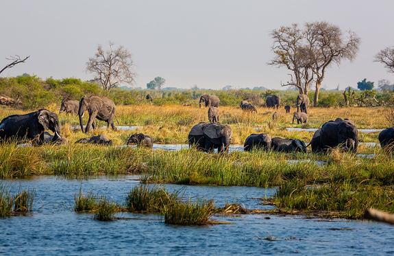
The Caprivi falls within the tropical climate zone with high rainfall during the rainy season (December to March). The region is rich in water, hosting diverse wildlife, including numerous elephants. Reserves like Bwabwata, Mudumu, Lizauli, and Mamili protect wildlife without border fences, allowing animals to roam freely into neighboring countries like Botswana and Zambia. Rundu on the Okavango River serves as the gateway to the Caprivi Strip, offering rich wildlife and plant diversity as well as cultural richness.
Divundu, located at the confluence of the Okavango and Kwando rivers, is known for wildlife sightings, Popa Falls, and the Mahango Game Park. Kwando, a village on the banks of the river of the same name, serves as a starting point for safaris in Mudumu and Mamili National Parks.
The Caprivi Strip, with its towns, offers visitors the opportunity to discover Namibia's natural beauty and wildlife, regardless of their interests in culture, adventure, or relaxation.
TIPS
The Living Museum of the Mafwe opened in 2008 and is a cultural highlight in the Caprivi Strip. In this authentic open-air museum, guests can explore the traditional culture and original way of life of the Mafwe people. The museum consists of a traditional village and the surrounding fields on a hill overlooking the Kwando River. Huge baobab trees provide shade while the Mafwe present their ancient culture in traditional attire. The performers at the Mafwe Living Museum engage with the offered program very interactively with great dedication, and the guide translates into English.

Divundu is a small village on the southeastern bank of the Kavango River, home to the Mbukushu kings. It is situated directly on the main artery connecting the Kavango region with the Zambezi region. The village itself is not particularly scenic, but travelers can stock up on supplies at the two general stores before exploring the Zambezi region.
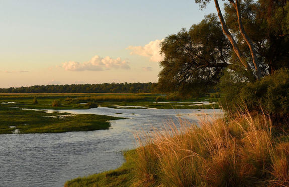
Before the Kavango River flows into Botswana, it plunges in a series of rapids, known as the Popa Falls, across its full width of 1.2 km. These are visible when the river is low during the dry season and are the main attraction near Divundu.
The river landscape is a paradise for birdwatchers, with about 430 species, almost 70% of the total number of bird species in Namibia, recorded here. The Okavango River, with its 71 fish species, is a very popular fishing spot, and the nearby Mahango Game Reserve offers a variety of wildlife in typical river and swamp habitats.
THINGS TO DO
- Birdwatching
- Fishing
- Wildlife viewing
- Boat trips
The largest wildlife reserve in the northeastern Namibian Caprivi Strip is the West Caprivi National Park, which was merged with the Mahango Game Reserve in 2007 and is now called the Bwabwata National Park. However, amidst this area dedicated to wildlife and plant protection, approximately 5,500 inhabitants also reside, posing a significant challenge for park management – after all, this entails balancing conservation efforts with human settlement. Covering an area of 6,274 square kilometers, the national park is the second-largest in Namibia.
The Bwabwata National Park is ideal for wildlife safaris due to its lack of fencing, which allows for constant wildlife movement and numerous opportunities to observe various species in their natural habitat.
In the Bwabwata National Park, you can encounter Namibia's last wild dogs, hippos, crocodiles, and numerous water birds. Some members of the "Big Five" are frequently spotted along the riverbanks: lions, elephants, buffaloes, and leopards – only rhinos are not found here. Instead, expect to encounter roan and sable antelopes, bushbucks, wildebeests, impalas, kudus, oryxes, elands, red lechwes, reedbucks, sitatungas, as well as smaller antelope and mammal species, which you can discover while they search for water.

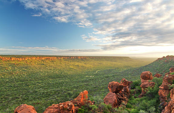
Situated in the Otjozondjupa Province, in the centre of what is known as the ‘Golden Triangle’, the towering Otavi Mountains are surrounded by the Northern Namibian towns of Otavi, Tsumeb, and Grootfontein, which are roughly 60 kilometres equidistant from each other. The landscape features golden maize plantations, spectacular dolomite mountains, and underground lakes.
Visitors to this spectacular region can look forward to a variety of activities including visiting the Hoba Meteorite, the largest ‘space object’ on earth and a national monument; explore Dragon’s Breath Cave which holds world’s largest underground lake; or viewing the bottomless ‘sinkhole’ Lake Otkikoto, boasting emerald green water is one of two permanent lakes in Namibia.
Visitors can also enjoy hiking, biking, fishing, off-roading, and game viewing safaris. Don’t miss the impressive Gaub Cave, filled with sensational stalactites and stalagmites.
The Waterberg Plateau, located east of Otjiwarongo, rises about 200 meters above the surrounding plains. This table mountain massif, 20 kilometers wide and 50 kilometers long, is composed of porous sandstone through which precipitation seeps into the permeable rock and encounters an impermeable layer of clay beneath.
While the plateau itself is relatively dry, there is abundant surface water and strong perennial springs at the base of the mountain. As a result, the vegetation here is comparatively lush, green, and highly diverse. Visitors can observe wild fig trees, flame lilies, and coral trees, among others.
Since 1972, the approximately 400-square-kilometer Waterberg area has been under nature conservation, and endangered species have been reintroduced. These include both black and white rhinos, sable and roan antelopes, as well as plains zebras.
The Waterberg Plateau Park offers excellent opportunities for hiking and relaxation. It features an excellent rest camp with a restaurant, beautiful and affordable holiday cottages, a swimming pool, and a campsite.
The Waterberg region also holds historical significance as it was traditionally inhabited by the Herero people. During the German-Herero conflict in August 1904, about 40,000 Herero men, women, and children, under the leadership of Samuel Maharero, were trapped by 1,600 German colonial soldiers at Waterberg and decisively defeated in a dramatic battle. Only a few Herero managed to escape through the Kalahari Desert to Botswana. Today, a military cemetery bears witness to the tragic events of that time.

The Onguma Game Reserve is a popular destination for wildlife viewing, located adjacent to the eastern side of Etosha National Park in Namibia. Spanning an area of about 34,000 hectares, it offers visitors a unique safari experience.
Onguma is renowned for its diverse landscape, which includes open plains, mopane woodlands, and dense bushland. The reserve is home to a wide variety of wildlife species, including elephants, lions, leopards, giraffes, zebras, wildebeests, and numerous bird species. Visitors have an excellent opportunity to observe these fascinating animals in their natural environment.
One of the main attractions of the Onguma Game Reserve is its immediate proximity to Etosha National Park. The eastern side of Onguma borders Etosha, allowing wildlife to roam freely between the two areas. This free movement enhances the chances of spotting a wide range of animals.
Another highlight of Onguma is the strategically positioned photographic hides at waterholes. These hides offer photographers and wildlife enthusiasts a fantastic opportunity to capture stunning close-up images of wildlife without disturbing their natural behavior.
In addition to wildlife experiences, Onguma Game Reserve also offers cultural encounters and opportunities for relaxation. Cultural tours to nearby villages provide insights into the traditions and customs of local communities, while wellness facilities and swimming pools in the lodges allow guests to unwind and rejuvenate after exciting game drives.
Overall, Onguma Game Reserve provides a remarkable blend of wildlife adventure, cultural exploration, and relaxation, making it an ideal destination for nature lovers and safari enthusiasts.
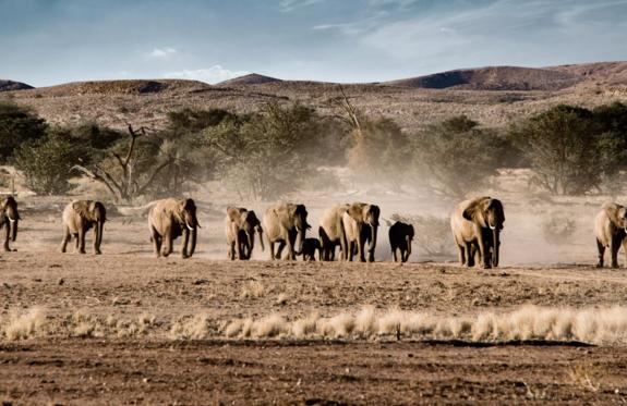
The Etosha National Park is a true paradise for wildlife enthusiasts. Covering an area of approximately 22,000 square kilometers, the park is home to an impressive variety of wildlife. Its main attraction, the Etosha Pan, is an expansive salt pan that offers a unique and fascinating landscape, making it a renowned spot for wildlife observation. Visitors to the Etosha National Park have the privilege of experiencing a wide range of animals in their natural habitat. Here is a list of the most commonly found species in the park:
Elephants | Lions | Black Rhinoceros | White Rhinoceros | Giraffes | Zebras | Oryx | Wildebeests | Impalas | Leopards | Cheetahs | Hyenas | Jackals | Flamingos | Springboks | Hartebeests | Kudus | Pelicans | Hornbills | Eagles | Vultures
These animals roam through savannah-like landscapes, visit waterholes, and provide an impressive spectacle in the Etosha National Park. Herds of elephants pass by, lions rest in the shade, and zebras and giraffes graze. The park offers endless opportunities to observe wildlife in their natural environment. Bird enthusiasts will also be thrilled by the diversity of birdlife, from majestic raptors like eagles and vultures to colorful flamingos in the vast Etosha Pan.
GATES OF THE ETOSHA NATIONAL
There are several entrance gates to the Etosha National Park. In the east lies the Andersson Gate, and in the west, the Galton Gate, named after the explorers Charles Andersson and Francis Galton. The Von Lindequist Gate in the east was named after the governor of German South West Africa, who declared Etosha a protected area in 1907. The Nehale Lya Mpingana Gate near the Andoni Plains is named after a king of the former Ovambo country.
Etosha Trading Post (Southern Entrance Etosha NP): As the name "Trading Post" suggests, the recently opened shop and gas station are places of exchange. The shop offers visitors all the essential groceries, snacks, and souvenirs. The entire building is designed in a historical style, where past and present merge... all located in a strategically perfect location just 10 km from the Andersson Gate, the southern entrance to the national park.

Located just south of the boundary of Etosha National Park in northwestern Namibia, Etosha South makes up the southern region of this wild paradise. The area is comprised of a collection of world class private game reserves. The national park can be accessed via the southern entrance at Andersson’s Gate. Visitors can catch a glimpse of a variety of wildlife including: lion, giraffe, elephant, white and black rhino, and a multitude of plains game. Popular activities include: enjoying an open 4x4 safari with an expert guide, half day or full day drives with the option of a picnic lunch with wine on the full day game drive.
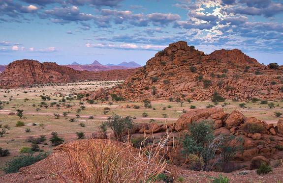
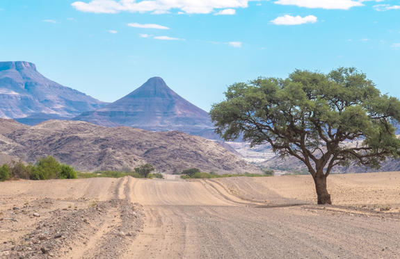
Damaraland is renowned for its breathtaking landscape, fascinating wildlife, and rich culture. The region boasts spectacular rock formations, rugged canyons, and vast plains, allowing visitors to experience the unique beauty of the Namib Desert landscape. Damaraland is also home to impressive animal species such as desert elephants, desert lions, and black rhinos. Additionally, there are prehistoric rock engravings and fossils to discover, providing insights into the region's long history. The cultural diversity of Damaraland is evident in the traditional Himba villages, where visitors can learn more about the lifestyle and customs of this fascinating ethnic group.
Khorixas serves as the center of Damaraland, stretching between the Erongo Mountains and the Etosha Pan in the northwest of the country. The name dates back to the era of the "Homelands," and today, Damaraland falls under the administration of the Kunene Region. The area is predominantly inhabited by the Damara people, who, along with the San (Bushmen), are among the oldest inhabitants of Namibia. Their language belongs to the Khoisan dialects, related to the languages of the Nama and San peoples. Khorixas itself, apart from a gas station, some shops, a rest camp, and a lodge, does not offer major highlights. However, the mountainous and rocky region surrounding Khorixas is home to several outstanding natural attractions, such as the Basalt Columns, known as the "Organ Pipes," located a few kilometers from Twyfelfontein, and the "Petrified Forest" with its 300 million-year-old tree trunks.
THINGS TO DO
- Visit the UNESCO World Heritage Site in the Twyfelfontein Rock Engravings Area
- Hiking and trekking tours
- Visit to a traditional Himba village
- Excursion to Spitzkoppe
This small town in the Southern Kunene Region of Namibia was once the capital of Damaraland and is home to around 6000 inhabitants, most of whom are from the Damara ethnic group. While the tiny town itself provides travel necessities at the local supermarket, bank, and petrol station, the surrounding area is a nature lover’s paradise with a variety of tourist attractions including the bizarre Welwitschia mirabilis at Burnt Mountain, rare stone formations, the petrified forest, ancient rock engravings and as well as many fascinating geological phenomena (make sure to see the 'Organ Pipes'). Khorixas is the epitome of a Namibian rural town. It marches to a slow African rhythm and its wonderfully friendly locals offer a warm welcome to all guests.

Twyfelfontein, located in Namibia’s Kunene Region, is a site of extraordinary cultural and historical significance. Known for its rich collection of over 2,500 prehistoric rock engravings, Twyfelfontein is one of Africa’s most important archaeological sites and a UNESCO World Heritage site.
Visitors can explore the beautifully preserved petroglyphs depicting animals, humans, and mysterious geometric patterns, thought to have been created by hunter-gatherers over 6,000 years ago. The red sandstone rock formations, set against the backdrop of rugged desert landscapes, add to the region's dramatic natural beauty.
In addition to its archaeological significance, Twyfelfontein offers visitors the chance to see rare desert-adapted wildlife, including elephants, giraffes, and oryxes. Guided tours are available, giving travelers the opportunity to delve deeper into the history and culture of this fascinating area.
Nearby Attractions:
- The Petrified Forest: A unique site with ancient fossilized trees.
- The Organ Pipes: Striking dolerite columns formed by volcanic activity.
- Burnt Mountain: A dark, eerie-looking hill with unusual geological features.
Whether you are a history enthusiast or a nature lover, Twyfelfontein provides a captivating experience that combines the ancient past with the rugged beauty of Namibia's desert wilderness.

Swakopmund is a charming coastal town and a popular destination for tourists from all over the world. The city blends German colonial architecture with African flair and offers a variety of activities and attractions. Situated on the coast on the edge of the Namib Desert, the city provides a wonderful view of the Atlantic Ocean. The towering sand dunes and rugged coastline offer numerous opportunities for activities such as sandboarding, quad biking, and dune hiking. Swakopmund is also renowned for its excellent restaurants and cafes, where you can enjoy both Namibian and international cuisine. Be sure to taste local specialties made from fresh fish and seafood.
THINGS TO DO
- Dolphin Cruise (mola-namibia.com)
- Tommy’s Living Desert Tour (livingdeserttours.com.na)
- Excursion toWalvis Bay
- Fat Bike Tours (https://www.swakopfatbiketours.com/)
RESTAURANT TIPPS
- The Tug (www.the-tug.com)
- Kücki’s Pub (www.kuckispub.com)
- Jetty 1905 (www.lighthousegroup.com.ca)
- The Wreck Restaurant (www.the-wreck.com)
- Village Cafe (www.villagecafenamibia.com)
OUR TIP
Quad biking with Desert Explorer: Looking for a bit of adrenaline? Then join Desert Explorer on a tour through the fascinating dune landscape around Swakopmund. One to three-hour quad bike tours are offered with experienced guides (www.namibiadesertexplorers.com).

Walvis Bay, originally discovered by Diaz in 1487 and founded by the Cape Dutch in 1793, was later annexed by the British. After Namibia's independence, the deep-sea port remained under South African control until it was returned to Namibia in 1994. Today, the town has around 40,000 residents and is located about 30 km from Swakopmund. Walvis Bay is a bustling town with a modern port and a thriving fishing industry. The salt flats in the area produce 400,000 tons of salt annually.
The town offers several attractions, including a local history museum, the Birdlife Information Centre, and the 1880-built Rhineland Mission Church. One of the most impressive features of Walvis Bay is its large lagoon, home to over 120,000 birds, including flamingos and pelicans. "Dune 7" on the outskirts of town is the highest sand dune in the area and provides a spectacular view at sunrise or sunset.
Walvis Bay also boasts numerous good restaurants, cafés, and bars, as well as comfortable hotels and guesthouses. A highlight of the area is the adventurous trip to Sandwich Harbour, a freshwater lagoon surrounded by dunes. The trip requires a 4x4 vehicle due to the deep sand, and the final stretch must be completed on foot.
THINGS TO DO
- Sandwich Harbour and Topnaar Cultural 4x4 Tour
- Marine Dolphin Cruise: https://www.mola-namibia.com/marine-dolphin-cruise
- Seal Kayaking @ Pelican Point: https://desertdunesdust-tours.com/half-day-tours/

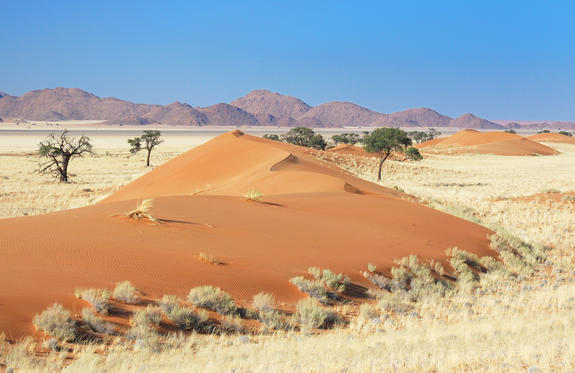
The Sossusvlei region lies in the heart of the breathtaking Namib Desert and is renowned for its extraordinary beauty and majestic landscapes. Sossusvlei is a dry clay pan surrounded by massive sand dunes, including the famous Dune 45, which is among the highest in the world. The landscape of Sossusvlei is characterized by impressive diversity. The red-orange sand dunes create a striking contrast with the blue sky and the white clay floors. The play of light and shadow throughout the day produces spectacular color displays, especially at sunrise and sunset.
In addition to Dune 45, the Sossusvlei region features other unique natural attractions such as Dead Vlei, a dried-up clay pan with petrified tree trunks that have been lying in the desert sun for centuries. This surreal backdrop offers photographers and visitors unparalleled opportunities to capture the beauty and tranquility of the desert. The Sossusvlei region is a paradise for nature lovers and adventurers. Numerous activities are available, including dune hikes, photo tours, stargazing, and even hot air balloon rides to explore the impressive landscape from a bird's-eye view.
Sesriem is a small settlement that serves as the gateway to the Sossusvlei region and the Namib-Naukluft National Park. It is located about 65 kilometers southwest of Solitaire and is a popular starting point for visitors wishing to explore the spectacular sand dunes and desert landscapes of the area. The name "Sesriem" refers to the six leather straps that early settlers tied together to draw water from the deep gorges surrounding the Tsauchab River. These gorges are now known as Sesriem Canyon, offering a fascinating sight with high rock walls and a dried-up riverbed.
Sesriem is also known for its picturesque campsites, lodges, and guest farms, which provide comfortable accommodations amid the desert landscape. Many of these accommodations organize guided tours to nearby attractions, including the Sossusvlei dunes, Dead Vlei, and Sesriem Canyon.
WILDLIFE IN THE REGION: Desert Elephants | Oryx Antelopes (Gemsbok) | Springbok | Ostriches | Desert Lions | Jackals | Geckos & Lizards | Snakes

As there is no accommodation at Sossusvlei, visitors to this desert wilderness are likely to end up staying at Sesriem, 65 kilometres away, where camps and lodges serve as a base from which to explore the dunes. Sesriem Canyon, a deep chasm carved through the rocks by water, is a striking natural feature of the area that is best explored on foot. Stony walls rise up sharply on both sides of the canyon, while birds roost in its crags and lizards dart along the ledges. The canyon’s name was coined when early settlers used it as a water source, using six lengths of leather (‘ses riem – six thongs) tied together to lower buckets into the water at the base of canyon.)

The NamibRand Nature Reserve stretches over an area of approximately 200,000 hectares in the southern part of the Namib Desert. It is a place of remarkable beauty, renowned for its fascinating landscapes and rich wildlife. Established in 1984 by Namibian landowners who recognized the importance of protecting the unique desert landscape and its diverse wildlife, the reserve stands as an outstanding example of sustainable conservation and communal development.
One of the most striking features of the NamibRand Nature Reserve is its majestic sand dunes, which stretch across the land, creating a surreal backdrop. These high, constantly shifting dunes often appear in various shades of red, orange, and gold, offering a breathtaking sight at sunrise and sunset. The reserve is home to an impressive variety of wildlife adapted to the harsh desert conditions. Cheetahs, desert elephants, giraffes, oryx antelopes, springboks, and many other species find their habitat here. Wildlife viewing in the NamibRand Nature Reserve is a special experience, as the animals move freely and undisturbed in their natural environment.
Another highlight of the reserve is the night sky. With minimal light pollution, the NamibRand Nature Reserve provides an incredible opportunity to admire the clear night sky with its countless twinkling stars. It is a paradise for stargazers and astronomy enthusiasts who wish to experience the beauty of the universe in all its glory.
Visitors to the NamibRand Nature Reserve can participate in a variety of activities. Guided walks take guests through the fascinating desert landscape, allowing them to discover the unique flora and fauna of the reserve. Game drives offer exciting wildlife encounters and the chance to capture these fascinating moments with a camera. The NamibRand Nature Reserve is a place of unparalleled beauty and rugged, captivating wilderness, enchanting adventurers and nature lovers alike.
Situated in southwestern Namibia at the edge of the world-renowned Namib Desert, the Tiras Mountains provide the perfect backdrop for visitors who venture to this red granite wonderland and immerse themselves in the natural beauty of this region. Namibian landscapes are synonymous with tranquility, serenity and endless open spaces and the magnificent Tiras Mountains encapsulate this quiet charm. Nature lovers flock here for an off-the-beaten-track experience in one of Namibia's most beautiful areas. Visitors can enjoy thrilling 4X4 mountain and dune tours, nature walks, game and bird viewing as well as excursions through quiver tree forests and to ancient rock paintings on granite rocks. Visitors can relax at one of the luxurious farm lodges after a wonderful day of activities, or get up close with nature while camping in this beautiful desert wilderness.

The Fish River Canyon is the second largest canyon in the world after the Grand Canyon in the USA. It is part of the state-run Ais-Ais Richtersveld Transfrontier Park. The entrance to the park is located 10 kilometers from the well-known viewpoint called Hell's Bend at the Hobas Restcamp.
The Fish River Canyon National Park, officially known as Ai-Ais National Park, covers a total area of 6,045 km², providing a protected area for Karoo succulents and endemic wildlife. To experience the beauty and serenity up close, lace up your hiking boots and embark on a private journey along the canyon. Unfortunately, day visitors are not allowed to hike into the canyon. Guided expeditions are also offered from April to September.
The Fish River is 800 kilometers long, making it the longest river in Namibia. It originates in the eastern parts of the Naukluft Mountains and flows for about 200 km before reaching the Hardap Dam, the largest water reservoir in the country, with a circumference of 30 km and an area of 28 km². The Fish River Canyon begins at Seeheim, at the lower reaches of the river. The canyon stretches for 161 km, is 27 km wide, and reaches depths of up to 550 meters. It ends at Ais-Ais, where the river flows into the Orange River, forming the border with South Africa.
About 650 million years ago, an impressive mountain range was shaped by the forces of erosion, eventually giving way to a vast plain flooded by the sea. However, it wasn't until about 350 million years later that a fascinating biological process set the formation of the Fish River Canyon in motion. Ancient tectonic faults opened up a massive trench, which expanded over time. Thus, the wide, ancient valley of the mighty Fish River was formed. The edges of this trench, now more than 20 km apart, mark the imposing cliffs that shape the canyon.
Originally, the riverbed was about 300 meters higher than it is today around 300 million years ago. Shortly thereafter, the Gondwana Ice Age began, further deepening the mighty glacial trench. Today, it is almost unimaginable to picture ice or glaciers in this breathtaking gorge—a contrast that makes the incredible history and transformation of the Fish River Canyon all the more fascinating.
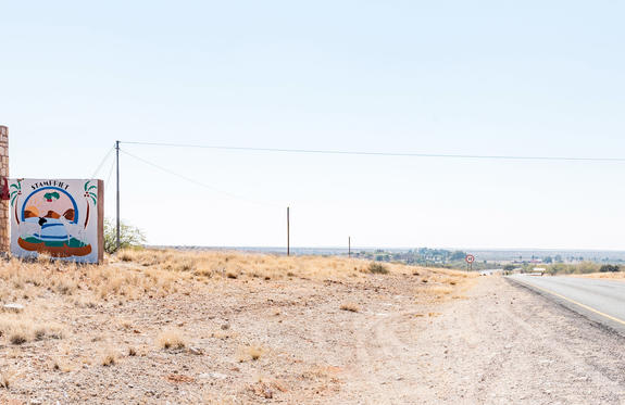
Stampriet is a tiny rural town in the Hardap Region of Namibia, which lies over the banks of the Auob River roughly ten kilometres north of Mariental. Founded in 1898 as a trading post in what was then German South-West Africa, the little town of Stampriet boasts a rich history and diverse culture. The town is best known for being the starting point of an amazing heritage route, which is scattered with memorials and battle sites of the war with the Germans, which took place between 1904 and 1907. The water flowing from the Kalahari and the plentiful boreholes of the area have made it possible to produce excellent fruit and vegetables here. The historic guest house is a must-see.

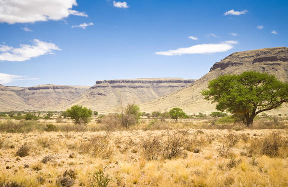
The Kalahari Desert, despite its name, receives a small amount of annual rainfall that is sufficient to support the growth of grasses and thorny shrubs. This vegetation provides food and shelter for the diverse wildlife that has adapted to this harsh environment.
The most characteristic feature of the Kalahari is its majestic sand dunes, which glow in a warm, reddish hue. These dunes stretch across a vast area, creating an otherworldly and impressive landscape. The sight of the dunes at sunrise and sunset offers a fascinating play of shadows and brings the colors of the desert to life. The silence and vastness of the Kalahari Desert give visitors a sense of seclusion and tranquility. Horizons stretch endlessly into the distance as you wander through open plains or along sandy paths.
The Kalahari Desert is home to a variety of wildlife adapted to the extreme conditions. Lions that hunt in the desert are known for their impressive manes and their ability to successfully hunt in the thorny bushland. Cheetahs, capable of breathtaking speeds, use the open grasslands of the Kalahari to chase their prey. Leopards, agile climbers, stalk their prey from trees and disappear skillfully into the dense bush. Hyenas roam the desert, playing a crucial role in scavenging carcasses, while meerkats, with their upright postures and curious behaviors, captivate onlookers. Springboks, with their distinctive ability to leap great distances, enliven the landscape, while gemsbok, with their long, curved horns, majestically traverse the plains.
ANIMALS IN THE DESERT
Lions | Cheetahs | Leopards | Hyenas | Meerkats | Springboks | Oryx | Ostriches | Jackals | Bats | Scorpions | Kudu Antelopes | Giraffes | Porcupines
In south‑central Namibia, Mariental is situated on the edge of the Kalahari, providing a serene, sun-drenched base for exploring vast desert landscapes. The town feels unhurried, with wide streets, warm hospitality and the ochre tones of the surrounding dunes never far from view. Travellers can venture into the Hardap Region for game drives and birdwatching around Hardap Dam, or opt for sunset dune walks/sundowner drives on nearby Kalahari reserves. The area’s semi-arid beauty reveals itself slowly, from the rustle of dry grasses to the shifting pastel hues of dusk. While facilities are modest compared with Namibia’s major safari hubs, Mariental rewards visitors with open horizons, gentle desert silence and an authentic sense of life on the Kalahari frontier.
