Today you arrive into Quito, Ecuador.
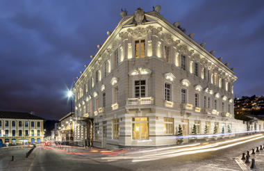
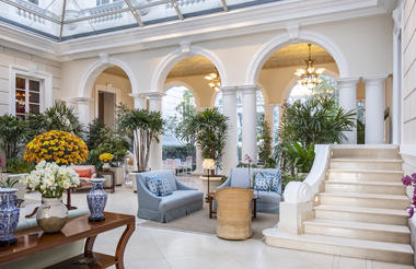
Once you have cleared immigration, collected your luggage and passed through customs, you will be met by your driver and transferred to Casa Gangotena for an overnight stay.
Overnight - Casa Gangotena
Today you depart Quito on the 3.5 hour drive to Mashpi Lodge.
Located on a scenic plateau, the lodge features breathtaking views of the surrounding forested mountains and their unique ecosystems. Like a cathedral to the natural world, Mashpi is a perfect blend of luxurious comfort and engagement with one of the world’s most stunning environs.
Mashpi Lodge is far more than just a five-star hotel in an exquisite location: you are accessing a research station that is at the forefront of rainforest protection, the Mashpi Reserve.
The wonders of Mashpi are yours to discover, to experience, to cherish, and the expedition leader and highly-trained naturalist guides – many of them native to the region – are here to share the journey with you.
Under the Documents Tab, you will find the Experiences brochures outlining what is available to you. You are free to combine them as you see fit. Upon arrival and every evening, you and your guide will meet to discuss how you wish to spend your time here.
Overnight - Mashpi Lodge


After a leisurely morning you depart on the drive back to Quito. The remainder of the day is at leisure to wander the square and surrounds.
Overnight - Casa Gangotena


Breakfast
Today you set off on a half day tour of Quito.
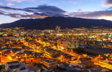
Quito was named as the first “World Cultural Heritage Site” in the world by UNESCO in 1978. This historical city has the largest and best preserved Historic Center and colonial quarters in Latin America. Quito’s Colonial Center features narrow streets lined with charming balconies filled with geraniums which enhance the beautiful and unique architectural elements that are emblematic elements of our historical legacy.
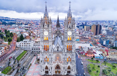
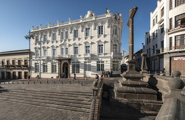
The excursion through Quito starts with a visit to the Gothic Basilica Church to enjoy its impressive architecture and a unique panoramic view of the Historic Center. After this visit you will take a walking tour through small, winding streets and romantic plazas to reach the Independence Square to continue with some of the most famous temples that are a part of the many major architectonic icons of this World Heritage Site.
Excursion Highlights:
- Quito’s Aerial Tram for a unique panoramic visit of the city and the Andes Mountain Range
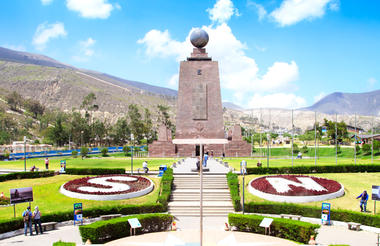
- the Intiñan Museum located right at the Middle of the World
- La Basilica Gothic Church
- La Plaza Grande (Quito Historic Center’s main Plaza)
- Visit to the emblematic Church of La Compañía
Overnight - Casa Gangotena
Breakfast
You’ll need to rise early this morning and transfer to Quito Airport to catch your flight to the Galapagos.
After passing through Galapagos National Park inspection your National Park Guide will be there to greet you, holding a sign with the name of your yacht. Your guide will accompany you on the short bus ride to the waterfront.
During WWII the island of Baltra was a US Air Force base and one can still see the remnants of the old foundations left behind from that era. You transfer via panga (launch) to the waiting M/Y Grace. The crew will see that your luggage is transferred to your cabin. At the dock you board a dinghy (panga) to make the short crossing to M/Y Grace. You only need to bring your carry-on luggage on the panga as the crew will transfer your luggage to your cabin.
You’ll have time to settle into your new home for the week before assembling to review safety procedures and coming events with your Galapagos National Park Guide. While this is taking place the M/Y Grace will start her engines and set off into the archipelago.
At the north end of Santa Cruz Island is Las Bachas, comprised of two sandy white-coral beaches that is are major egg-laying sites for sea turtles. The official story of how Las Bachas got its name comes from the Galapagos National Park.
During WWII the US military discarded two barges on the beaches. When the first settlers to the area following the war arrived they mispronounced barges as bachas, resulting in the name. There are other explanations of how the location got its name having to do with indentations left in the sand by both egg laying sea turtles and their departing hatchlings, but we will go with the Park’s.
You go ashore to the white sandy beach and are greeted by patrolling bluefooted boobies. A brief walk walk inland takes you to lagoon where pink flamingos are often found along with great blue herons, common stilts, brown noddys, white-cheek pintail ducks and migratory birds.
Snorkelling today is from the beach and you can also enjoy a swim in these waters, which are typically warmer than in other places in the Galapagos.
Overnight - M/Y Grace


Activities
a.m. | Morning: Fly to Baltra in the
Galapagos Islands and board Grace
Type of Landing: N/A
p.m. | Late Afternoon: Bachas Beach
Type of Landing: Wet
Activities: Hikes
Note on Galapagos Itineraries
To lessen the environmental impact on visitor sites, The Galapagos National Park has decided that vessels permitted to operate within the park cannot revisit the same site within 14 days. As a result our yachts now repeat the same itinerary every two weeks (instead of every week). They split the two week long itineraries in half so that two different 8 day/7 night voyages are operated from Tuesday to Tuesday. Itineraries are therefore alternated every other week. Both itineraries are excellent and those visiting the islands will be pleased with either choice. While there are always tradeoffs of what one can and cannot see during a weeklong trip through the Galapagos, you can now see almost everything by doing back to back itineraries aboard the Grace.
Tower Island could serve as a film set for a remote secret submarine base. The southwestern part of the island is an ocean-filled caldera ringed by the outer edges of a sizeable and mostly submerged volcano. The island sits to the northwest, slightly removed from the rest of the archipelago. It is also known as Bird Island, a name it lives up to in a spectacular way. Your first landing is Prince Phillip’s Steps, named for a visit by the British Monarch in 1964.
The dry landing begins at the base of this 25-meter (81-foot) stairway leading up to a narrow stretch of land that opens out onto a small plateau. This is actually a small peninsula that forms the southeastern section of the island. Red-footed boobies wrap their webbed feet around branches to precariously perch in the bushes where they nest. In contrast their masked-booby cousins dot the surface of the scrublands beyond.
Crossing through the sparse vegetation, you will come to a broad lava field that extends toward sea cliffs that form the island’s southern edge. The cavities and holes that have been eroded into the fragile lava are an ideal nesting ground for storm petrels. There are two species, the Galapagos petrel, which is active by day, and the wooden petrel, which feeds at night. The petrels flutter out over the ocean in swarms, then return to nest in the cracks and tunnels of the lava field but not without hazard. Short-eared owls lay in camouflaged wait here and make their living feeding off the returning petrels.
After completing the two hour hike you return to the vessel to change into your wetsuits for some snorkeling at one of the best sites in the islands. By Phillip’s Steps, along the cliffs that form the protected southern bay of the Tower’s caldera, you enter the water into another world. The first thing you will notice when snorkeling here are very large tropical fish. These are warm water fish feeding off cold water nutrients. You’ll find the full assortment here including oversize parrot, unicorn, angel and hogfish along with schools of perch, surgeon fish and various types of butterfly fish. Hiding in and around the rocky shoreline that drops off into the caldera you will also see a rainbow assortment of wrasse, basslet, anthias and tang. This is the place to bring your underwater tropical fish identification chart.
There are some special treats to be found here including occasional visits by fur sea lions. This area of the bay is also excellent for some kayaking in the calm waters close to the shore to observe nesting birds and you might like to go out for a spin after lunch, before your next landing across the bay to the north.
Landing on the white coral sands of Darwin Bay and walking up the beach, you find yourself surrounded by the bustling activity of great frigate birds. Puffball chicks and their proud papas—who sport bulging scarlet throat-sacks—crowd the surrounding branches, while yellow-crowned herons and lava herons feed by the shore.
Farther along you will discover a stunning series of sheltered pools set into a rocky outcrop. Watch your step for marine iguanas, lava lizards and Galapagos doves that blend with the trail. The trail beside the pools leads up to a cliff overlooking the ocean filled caldera, where pairs of swallow-tailed gulls, the only nocturnal gulls in the world, can be seen nesting at the cliff’s edge. Lava gulls and pintail ducks ride the sea breezes nearby. A brief panga ride brings you to the base of those same cliffs to reveal the full variety of bird species sheltering in the ledges and crevices created by the weathered basalt. Among them, red–billed tropic birds enter and leave their nests trailing exotic kite-like tails.
This is also an intriguing place to go deep-water snorkeling. The center of the caldera is very deep and attracts hammerheads and large manta rays which sometimes patrol the western edge of the caldera that is more open to the sea. You can snorkel here gazing down into the depths where you just may spot these large animals if you are fortunate. But don’t worry, if you don’t really want to see them there is the equally amazing and far more sheltered snorkeling experience across the bay.
Right around sunset you will leave Tower to set out across the archipelago to the far western islands. Remember to watch the inner bay at sunset as you might spot a giant manta ray.
Overnight - M/Y Grace


Activities
a.m. | Morning: Prince Phillips Steps
Type of Landing: Dry
Level of Walk: Moderate
Other Activities: Nature Hikes, Snorkeling, Panga Ride & Kayaking
p.m. | Late Afternoon: Darwin Bay
Type of Landing: Wet
Level of Walk: Moderate
Other Activities: Nature Hikes, Snorkeling, Panga Ride & Kayaking
- All meals and snacks throughout cruise
- Guides and activities throughout the cruise
- All transfers (with rest of group) while in Galapagos
- Soft drinks, juice, coffee and tea throughout the cruise
- Use of snorkeling equipment and wetsuits
- Use of kayaks
In the morning you make your way along the northwestern shore of Santiago Island to South James Bay (Puerto Egas), which offers access to three unique sites. One landing is on a black beach with intriguing eroded rock formations inland. A trail crosses the dry interior eastward and rises to the rim of an extinct volcanic crater; cracks within it allow sea water to seep in, which then dries to form salt deposits that have been mined in the past. Darwin describes his visit to South James Bay in Voyage of the Beagle.
Another path leads south, where hikers are treated to a series of crystal-clear grottos formed of broken lava tubes. These are home to sea lions and tropical fish. This is the best place in the islands to see fur sea lions lazing on the rocks by the grottos. Further to the north, another landing and path lead to a series of inland lagoons, home to flamingos. Birders coming to James Bay will have the opportunity to spot vermillion flycatchers, Galapagos hawks and the tool-wielding woodpecker finch. Puerto Egas is a good spot for taking pictures—the light for photography is perfect at either dawn or sunset. The lava and the black sand seem to catch fire and the animals acquire a surreal and lovely quality. The marine iguanas that inhabit the area resemble Samurai warriors and can easily be seen grazing on seaweed in the more shallow pools of the grotto.
James Bay is a snorkeling site that is accessed from the shore instead of a dinghy. The sandy beach slopes off into a rocky bottom where a multitude of sea turtles like to hide by blending in with the rocks. But these rocks move and will swim right up to you. At certain times of the year large schools of golden rays and spotted eagle rays also glide by. Both fur sea lions and California sea lions occasionally pass through as well.
In the afternoon visitors to Espumilla Beach come in search of birds rather than fresh water. The short walk up the beach leads inland to a mangrove typically inhabited by the Common stilts. Beyond the mangroves is a brackish lagoon where flocks of pink flamingos and white cheeked pintails wade in search of mollusks. The trail makes a passes over a tiny hilltop through a sparse Palo Santo forest before looping back to beach. Galapagos finches and Vermilion fly catchers inhabit the area.
The tuff formations that form the cliffs that surround the cove have created a natural sculptor gallery rising from the sea with formations including the Monk and Elephant Rock. An audience of hundreds of seabirds looks down upon the gallery from surrounding cliffs. Buccaneer Cove and Espumilla Beach offers one of the more dramatic kayaking routes in the Galapagos for paddlers looking for a challenge.
Overnight - M/Y Grace


Activities
a.m. | Morning: James Bay
Type of Landing: Wet
Level of Walk: Moderate
Other Activities: Nature Hikes & Snorkeling
p.m. | Afternoon: Espumilla Beach
Type of Landing: Wet
Level of Walk: Easy
Other Activities: Nature Hikes, Snorkeling
Located at the ‘mouth’ of the head of the sea horse, which forms the northern part of the Isabela is Punta Vicente Roca. Here the remnants of an ancient volcano forms two turquoise coves with a bay well protected from the ocean swells. The spot is a popular anchorage from which to take panga rides along the cliff where a partially sunken cave beckons explorers. Masked and blue-footed boobies sit perched along the point and the sheer cliffs, while flightless cormorants inhabit the shoreline. The upwelling of cold water currents in combination with the protection of the coves make Punta Vicente Roca one of the archipelago’s most sought after dive spots.
One cove is only accessible from the sea by way of an underwater passage. The passage opens to calm waters of the hidden cove where sea lions laze on the beach having traveled along the underwater route. The entire area of Punta Vicente Roca lies on the flank of 2,600 foot Volcano Ecuador. This is the island’s sixth largest volcano. Half of Volcano Ecuador slid into the ocean leaving a spectacular cutaway view of its caldera. The site offers deep water snorkeling where sea lions turtles, spotted eagle rays and even manta rays are the attraction. After our visit here we set off south and west across the Bolivar channel. Keep your eyes open in this best place in the islands for spotting whales.
Isabela is the largest island in the archipelago, accounting for half of the total landmass of the Galapagos at 4,588 square kilometers. Though narrow in places, the island runs 132 km from north to south, or 82 miles. Isabella is formed from six shield volcanoes that merged into a single landmass. It is also home to the highest point in the Galápagos, Wolf Volcano at 1,707 meters (5,547 feet), and calderas of up to 20 kilometers (12½ miles) across. You head north along the western coast of Isabela Island, to Tagus Cove, named for a British warship that moored here in 1814. Historically the cove was
used as an anchorage for pirates and whalers. One can still find the names of their ships carved into the rock above our landing, a practice now prohibited. The cove’s quiet waters make for an ideal panga ride beneath its sheltered cliffs, where blue-footed boobies, brown noddies, pelicans and noddy terns make their nests, and flightless cormorants and penguins inhabit the lava ledges.
From the landing, a wooden stairway rises to the trail entrance for a view of Darwin Lake; a perfectly round saltwater crater, barely separated from the ocean but above sea level! From the air one can see that both Tagus Cove and Darwin Lake are formed from one, partially flooded, tuff cone on the eastern edge of giant Darwin volcano.
The cove is formed by a breached and flooded section of the crater with Darwin Lake forming the very center of the same cone. The trail continues around the lake through a dry vegetation zone, and then climbs inland to a promontory formed by spatter cones. The site provides spectacular views back toward your anchorage, as well as to Darwin Volcano and Wolf Volcano to the north.
While one does not normally think of greener pastures when planning to go snorkeling, that is exactly what you will find at Tagus Cove. The carpet of green algae that covers the floor of the cove gives the impression of a submerged pasture, and really that is just what it is. You can find marine iguanas grazing the algae along with numerous sea turtles gliding and munching their way along. Because the cove opens to the rich waters of the Bolivar Channel this is one of the best snorkeling sites in the island. You also have a good chance of snorkeling with underwater feathered friends including Galapagos penguins and rare flightless cormorants. For those who want to dive deeper there are special rewards waiting for you at 3 meters where camouflaged creatures await, including scorpion fish nestled against the outcrops and sea horses masquerading as twigs of the seaweed waving in the currents. The rare Port Jackson shark can also be found here.
Kayakers can enjoy a paddle around the cove, offering excellent views of nesting birds on the cliff walls above.
Overnight - M/Y Grace


Activities
a.m. | Morning: Punta Vicente Roca
Type of Landing: Wet
Level of Walk: Easy
Other Activities: Snorkeling, Panga Ride
p.m. | Afternoon: Tagus Cove
Type of Landing: Dry
Level of Walk: Moderate
Other Activities: Nature Hikes, Snorkeling, Panga Ride & Kayaking
Fernandina is the youngest and westernmost island in the Galapagos. It sits across the Bolivar Channel opposite Isabela. Your destination is Punta Espinosa, a narrow spit of land in the northeast corner of the island, where a number of unique Galapagos species can be seen in close proximity. As your panga driver skillfully navigates the reef, penguins show off by throwing themselves from the rocks into the water. Red and turquoise-blue zayapas crabs disperse across the lava shoreline, while great blue and lava herons forage through the mangrove roots.
The landing is a dry one, set in a quiet inlet beneath the branches of a small mangrove forest. A short walk through the vegetation leads to a large colony of marine iguanas—a schoolyard of Godzilla’s children— resting atop one another in friendly heaps along the rocky shoreline, spitting water to clear their bodies of salt. Nearby, sea lions frolic in a sheltered lagoon.
Dominating this landscape from high overhead looms the summit of La Cumbre, 1,495 meters (4,858 feet), one of the most active volcanoes in the world. Farther down this stretch of shore, the world’s only species of flightless cormorants have established a colony near an inviting inlet frequented by sea turtles. Because these birds evolved without land predators—it was easier to feed on the squid, octopus, eel and fish found in the ocean—the cormorants progressively took to the sea. They developed heavier, more powerful legs and feet for kicking, serpent-like necks and fur-like plumage. Their wings are now mere vestiges. Back toward the landing and farther inland, the island’s black lava flows become more evident, forming a quiet, inner mangrove lagoon where you will spot rays and sea turtles gliding just below the surface. Galapagos hawks survey the entire scene from overhead.
The snorkeling off Punta Espinoza offers some real treats, as many of the creatures you just saw on land, including the Godzilla-like marine iguanas, flightless cormorants, Galapagos penguins and sea lions await you in the waters off the point (which incidentally was used as a set during the making of Master & Commander). A key feature of the ocean bottom here are the troughs formed by volcanic rock and ocean currents. Because these waters reach out into the Bolivar Channel they can be quite cold. Sea turtles like to hang out in the warm water of the troughs.
You’ll also see marine iguanas ferrying back and forth between underwater grazing areas and their colonies on shore. This is an excellent place to see underwater iguanas munching on algae. If you are fortunate you may catch a glimpse of a flightless cormorant demonstrating their swimming abilities or watch a Galapagos penguin zip by. You will feel the difference in ocean temperature and watch the water get clearer as you move from the more protected shallow areas out into the cold rich waters of the channel. The Bolivar Channel is the very best place in the Galapagos to see dolphins and whales. On rare occasion our groups have been able to swim with dolphins, kayak with melon headed whales and even spot the elusive sperm whale.
Urbina Bay is directly west of Isabela’s Volcano Alcedo, where you make an easy, wet landing (a hop into a few inches of water) onto a gently sloping beach. In 1954, a Disney film crew caught sight of this gleaming white strip, and went to investigate. To their astonishment, three miles (5 km) of the marine reef had been uplifted by as much as 13 feet (4 meters) prior to their arrival. They discovered schools of stranded fish and other creatures in newly formed tidal pools along with the skeletons of sea turtles and sharks unable to make it to the ocean as a result of the uplift event. Alcedo erupted a few weeks later.
Now visitors can walk amongst the boulder sized dried coral heads, mollusks and other organisms that once formed the ocean floor. A highlight of this excursion is the giant land iguanas, whose vivid and gaudy yellow skin suggests that dinosaurs may have been very colorful indeed. Giant tortoises inhabit this coastal plain during the wet season, before migrating to the highlands when it turns dry. Your landing beach provides a nesting site for sea turtles and will also provide you with opportunities to snorkel amongst marine creatures, or just relax on shore. Here you must take care not to step on the sea turtle nests dug carefully into the sand. For those looking for snorkeling from a beach this is the place, with tropical fish hiding amongst the rocks to the north side of the bay.
This evening you have a real treat as the Grace sits at anchor in the Bolivar Channel where you will be spectacularly surrounded by the towering shield volcanoes that form Fernandina and Isabela. Sunset in the channel is also an excellent time to spot whales and dolphins that feed in these productive waters created by the upwelling of the Cromwell Current, while you enjoy a happy hour at the Sky lounge on the upper rear deck.
Overnight - M/Y Grace


Activities
a.m. | Morning: Punta Espinoza
Type of Landing: Dry
Level of Walk: Moderate
Other Activities: Nature Hikes & Snorkeling
p.m. | Afternoon: Urbina Bay
Type of Landing: Wet
Level of Walk: Easy
Other Activities: Nature Hikes & Snorkeling
Continuing your voyage south along the west coast of Isabela you enter the outer part of Elizabeth Bay where you come upon a tall rocky islet that is home to a colony of Galapagos Penguins. Looming to the south is Sierra Negra volcano that forms the southern part of Isabela Island. In 2018 glowing rivers of lava lit up the night as they flowed down the flank of Sierra Negra toward Elizabeth Bay, where some lucky passengers had a front row seat on one of the archipelagos most spectacular performances.
In contrast to the rugged lava fields of Sierra Negra, Elizabeth Bay is one of the most sensitive habitats in the Galapagos. This outing is entirely aboard the pangas. The tangle of mangroves roots that line the Bay, as it narrows to a channel before widening out to the back bay, tend to still the waters making it seem like a giant aquarium, while giving the area a green forested look. Spotted eagle rays, golden rays and sea turtle glide just below the surface with the latter coming up occasionally to breath. You may see a Galapagos hawk circling high overhead as we drift the calm waters. Approaching the back of the Bay, we bring the panga closer into a cluster of mangroves for a surprise. Sealions use the horizontal trunks of the mangroves as resting areas earning them the nickname tree lions.
You return to the Grace for lunch as she makes her way a bit farther along the coast of Isabela to your next visitors’ site, Punta Moreno. You’ll likely be surprised at just how much life you can find in and around a pahoehoe lava field. In 2018 Sierra Negra Volcano, which looms over the entire southern part of the island (and really is the southern part of the island) gave the area a fresh coat of glowing lava that reached within 3 miles of your landing site. This is one of the least visited sites in the Galapagos.
Overnight - M/Y Grace


Activities
a.m. | Morning: Elizabeth Bay
Type of Landing: N/A
Level of Walk: N/A
Other Activities: Panga Ride
p.m. | Afternoon: Punta Moreno
Type of Landing: Dry
Level of Walk: Moderate
Other Activities: Nature Hikes, Snorkeling & Panga Ride
Santa Cruz, your next stop, is the second largest island in the Galapagos and something of a hub for the archipelago. Baltra, where one of the archipelago's two airports is found, is on the far north end of the island. Puerto Ayora, located in the south of this large, round volcanic island is the seaside economic center of the Galapagos, focused on fishing and tourism. The little port town offers restaurants, hotels, souvenir shops, internet cafés and a place to get your laundry done!
This morning you visit Puerto Ayora, home to both the Galapagos National Park Service Headquarters and Charles Darwin Research Station, the center of the great restorative efforts taking place in the park, and a UNESCO World Heritage site. Here you visit the Giant Tortoise Breeding & Rearing Programme run by the research station, which began by rescuing the remaining 14 tortoises on the island of Española in 1970. This programme has restored the population of animals there to over 1,000 today. You will see many of these animals, with their sweet ET necks and faces; from hatchlings to juveniles to large, distinguished individuals. This is where famed tortoise, Lonesome George, lived out his last days as the last of his particular race of tortoise.
A highlight of any trip to the archipelago is a visit to the Santa Cruz Highlands, where the sparse, dry coastal vegetation transitions to lush wet fields and forests overgrown with moss and lichens. The afternoon destination is the Wild Tortoise Reserve where you will have chances to track and view these friendly ancient creatures in their natural setting. This extends to the adjacent pasturelands, where farmers give tortoise safe quarter in exchange for allowing paying visitors to see them.
When viewing the tortoise in their natural setting you are literally scratching the surface because there is another world awaiting you beneath the highlands. Lava tubes are formed when the outer surface of a lava flow cools, insulating the interior lava, which continues to flow on leaving a hollow tube as the result. The tubes become covered with earth over time and the result is a perfectly formed underground tunnel courtesy of Mother Nature. A wooden stairway descends to the mouth of the arched entrance to one of these underground passages and continues to the narrow opening that marks its exit. There are lights to show you the way but it’s also a good idea to bring a flashlight.
The terrestrial world of the tortoise and underworld of the lava tubes meet at Los Gemelos (the twins). These two large sinkholes craters were formed by collapsed lava tubes. The contrast between the marine desert coast and verdant Lost World look of the highlands is most striking here and you can easily encounter rain even when sun is shining a half an hour away at the coast. Los Gemelos are surrounded by a Scalesia forest. Scalesia is endemic to Galapagos and many endemic and native species call the forest home. This is an excellent place to view some of Darwin’s famous finches along with the elusive and dazzling vermillion flycatcher.
You return to Puerto Ayora with time for shopping, visiting an internet café or simply enjoying this little port town near the edge of the world.
Overnight - M/Y Grace


Activities
a.m. | Morning: The Charles Darwin
Research Station.
Type of Landing: Dry
Level of Walk: Easy
Other Activities: Shopping in Puerto Ayora
p.m. | Late Afternoon: Highlands.
Type of Landing: Dry
Level of Walk: Easy
Other Activities: Nature Hikes
Today you say goodbye to the Grace to take a 40 minunte bus ride early in the morning to visit Los Gemelos. The terrestrial world of the tortoise and underworld of the lava tubes meet at Los Gemelos (the twins). These two large sinkholes craters were formed by collapsed lava tubes. The contrast between the marine desert coast and verdant Lost World look of the highlands is most striking here and you can easily encounter rain even when sun is shining a half an hour away at the coast.
Los Gemelos are surrounded by a Scalesia forest. Scalesia is endemic to Galapagos and many endemic and native species call the forest home. This is an excellent place to view some of Darwin’s famous finches along with the elusive and dazzling vermillion flycatcher.
After visiting Los Gemelos, we continue the bus ride for another 20 mins to the Itabaca channel. You will cross the channel and take a short bus ride to Baltra’s airport.
You fly from Baltra to Quito Airport and check in for your homebound flight.
End of Arrangements